Showing posts with label FY2024 monthly exhibit. Show all posts

Monday, June 3, 2024

On Display in the State Library - The Massachusetts Mercury

Step back in time with this month’s Collection Spotlight item. On display for the month of June is a bound volume of The Massachusetts Mercury from 1796, open to show the front page from June 21 and the last page from May 24. Take a look at the pages to see the advertisements, news articles, and shipping departure schedules that Bay Staters would have reviewed themselves over 225 years ago!

The Massachusetts Mercury was a tri-weekly newspaper, founded in 1793 and published once every three weeks by Alexander Young and Thomas Minns from their office on State Street in Boston. Following The Massachusetts Mercury through time can be a little confusing, as over the years it changed names numerous times and merged with other papers. Young and Minns were the publishers for several years and the paper was known as The Massachusetts Mercury until 1800 when its name changed to The Mercury and New-England Palladium. It was then known as The New-England Palladium from 1803 until 1814, followed by The New-England Palladium & Commercial Advertiser until 1840, when it merged with other newspapers to become The Boston Semi-Weekly Advertiser. At the time of the displayed 1796 publication, the nameplate included the Latin phrase “dulcique animos novitate tenebo” which one of our staff members was able to translate as “and I will possess an open mind towards unfamiliarity” which seems like a fitting motto for newspaper readers.

Since the volume is bound, it is displayed open to show both the last page of the May 24 edition and the front page of the June 21 edition. Because the paper was published only once every few weeks, the content spans a range of dates. The news section includes events that have occurred since the last printing, and the advertisements and notices of auctions are for upcoming dates weeks into the future. Looking closer at the content, the front page shows a surprising amount of information about ships, both listings of departure dates and destinations of passenger vessels, and advertisements to buy vessels, which emphasizes Boston's role as a port city. A fun detail is that each listing also includes a small etching of the ship mentioned! Beginning on the front page and continuing onto the interior pages are international and domestic news, with a heading reading "The foreign news in this day's Mercury will well reward an attentive person. The domestic news is all interesting." The last page is full advertisements, similar to the classified section of modern newspapers, along with a few marriage and death notices. The advertisements provide a glimpse into life in Boston at the end of the 18th century, letting us read first-hand about the types of goods and services that were offered. I've included an image below of an advertisement for watches and other jewelry.  


I like this listing because the address is 51 Newbury Street; in modern Boston, Newbury Street is known for its designer boutiques and elegant shopping, and would likely be your destination if you were looking for a fancy watch or jewelry.  But Newbury Street is part of Back Bay, which wasn't created until the 1860s. A little searching on the history of Boston streets revealed that in the 1700s, Newbury Street existed as part of what we now know of as Washington Street in the Downtown Crossing area of Boston. So even though it is not the same Newbury Street that exists today, it coincidentally would have still been the spot to visit if you were looking for fancy goods. 

As the Library’s Preservation Librarian, I love sharing items from our colonial newspaper collection as part of our outreach program, in part because they are often in remarkable condition given their age. Tour participants and social media followers are surprised to see items that are over two hundred years old in better condition than the 2004 Boston Globe that they saved to commemorate the Red Sox winning the World Series! We keep our newspapers in dark storage with controlled temperate and humidity, but the largest factor to their stable condition is that colonial newspapers were made of rag paper. Colonial paper was made from made from linen and cotton fibers or rags and is much more durable and stable than paper made from wood pulp and it doesn't become brittle or yellowed with age. It wasn’t a quick process, which is maybe why newspapers were only printed every three or four weeks!

Visit us throughout June to see The Massachusetts Mercury on display in our main reading room, and check out the full list of historical newspapers available in Special Collections here


Elizabeth Roscio
Preservation Librarian

Monday, April 29, 2024

Preservation Week at the State Library!

Happy Preservation Week! Established by the American Library Association in 2005, Preservation Week is a yearly event that raises awareness for preservation work undertaken in library, archives, and museums to safeguard our shared cultural heritage. Preservation Week is also a time to encourage the public to think about actions that they can take to protect their own personal collections. This year, it is celebrated from April 28 through May 4 with the theme "Preserving Identities." 

In our Collection Spotlight case, we’re kicking off Preservation Week by highlighting an item that has benefited from preservation work and also aligns with May’s designation as Asian American and Pacific Islander (AAPI) month. Last year, we shared a few facsimiles from an album titled “Photographs of Schools,” which was produced by the Hawaii Department of Education and donated to the State Library in July 1924. It comprises seventeen photographs of Hawaiian schools, teachers, and students dating from sometime between 1897 and 1922. This year, we’re sharing the album itself in our Collection Spotlight case. The reason that we can share the actual item instead of facsimiles is because our Collection Spotlight case is specifically designed to protect exhibited items. One of the largest threats to archival items is light damage, from both natural and artificial light sources, which accumulates over time and cannot be reversed. As such, it is optimal for archival items to remain in dark storage unless they are being accessed by a researcher - but this at odds with the desire to display archival items! Luckily, our Collection Spotlight case has been designed with this in mind, and its glass panel is “SmartGlass” which has UV filters and a layer of light-controlling film. When not in use, the glass portion of the case is dark, until it is activated by a button which lights the case for 30 seconds. This allows the case to remain dark for the majority of the time but illuminated when a visitor wants to view the exhibited item, allowing us to safely display even our more sensitive items, like the photograph album we’re sharing this month. Regular readers of our blog may have noticed that the contents of our Collection Spotlight case changes every month. This is another preventative preservation measure, as a monthly exhibit rotation limits the amount of time that an archival item spends out its controlled storage environment. 


Another way that this scrapbook has benefited from preservation initiatives is that it has been digitized. The most obvious benefit of digitization is that it makes our collection more accessible to a wider audience who can access it remotely, but from a preservation standpoint, it is also beneficial because it reduces the amount of handling that the item receives. The more an item is handled, the higher the likelihood is that it will be damaged. By having researchers access a digital surrogate, we can preserve the integrity of the original and ensure its longevity. We do some digitization on-site, but we also send larger projects to vendors off-site. 

This month, we’ve displayed the album open to a show an image of pupils in front of the Kawaiaha’o Common School (above) and an image of a few of the teachers grouped with a few students (right). The Common School was originally the Old Mission School House, founded in the 1830s by missionary Sybil Bingham.  Unfortunately, only two of the images can be exhibited, but the album in  its entirety can be viewed here. And another preservation note, if we were to exhibit this album again, we would select different pages to open it to. 

Stop by the library throughout the month of May to see this scrapbook on display, and follow along as we share preservation content on our social media channels all week! You can also check out our two preservation focused Flickr pages for examples of work done in our lab and preservation tips you can use at home.


Elizabeth Roscio
Preservation Librarian

Monday, April 1, 2024

On Display in the State Library - Poetry Month!

When you think of the State Library, a large poetry collection might not come to mind. And while poetry isn’t exactly one of our strongest collecting areas, we do have a respectable number, including some volumes that date from the 1700s and 1800s. This month, in celebration of April’s designation as Poetry Month, we’ve selected a few of those older volumes to share in our Collection Spotlight case. Visit us throughout the month to see The Boston Book, Being Specimens of Metropolitan Literature, The Waif: A Collection of Poems, and Astraea: The Balance of Illusion on display in our reading room.

National Poetry Month was established by the Academy of American Poets and held its first celebration in 1996. Through local events held throughout the country, displays within libraries and bookstores, and educational resources for schools, Poetry Month is a time to celebrate works of poetry (either already published or your own original creation) and the role of poets in society. In addition to the historical volumes displayed in our Collection Spotlight case, here at the State Library we are also sharing some contemporary publications, including the poetry winners from the Mass Book Awards, on the shelves when you first enter the library. Find more information about Poetry Month on the Academy’s website.

Within our Collection Spotlight case, you will find three volumes that date to the early-to-mid 1800s. The first is The Boston Book, which was published in Boston in 1837. This is the second in a series whose aim was to provide a compilation of examples of “the modern literature of the Metropolis of the North.” It is not entirely comprised of poetry, but is a mixture of essays, fiction, and poetry. We are displaying the volume open to the poem “New England” by John Greenleaf Whittier (1807-1892), who was a Quaker poet born in Haverhill, Massachusetts. Whittier was an abolitionist and is part of the group of poets referred to as the “fireside poets,” known for their themes of morality and domesticity, and the wide appeal of their topics, hence the whole family could gather around the fireplace to enjoy them together. In “New England” Whittier describes the landscape of his homeland in romanticized terms, like the stanza transcribed here: “Land of the forest and the rock – / Of dark blue lake and mighty river – / Of mountains reared aloft to mock / The storm’s career, the lightning’s shock – / My own green land forever!”
 
The Waif: A Collection of Poems was published in 1845 in Cambridge (MA) and was edited by Cambridge resident and poet Henry Wadsworth Longfellow. The volume begins with Longfellow’s poem “Proem” but it is a collection of primarily British poetry dating from the 1700s into the 1800s. Given the time of year, we’ve chosen to display the volume open to a poem titled “April” by an anonymous author. The poem describes April’s rainy tendencies, as well as the buds and blooms that burst forth as a result. One stanza reads, “I stood to hear – I love it well – / The rain’s continuous sound; / Small drops, but thick and fast they fell, / Down straight into the ground.” And another, “The very earth, the steamy air, / Is all with fragrance rife; / And grace and beauty everywhere / Are flushing into life.” We think this is an apt description of April’s weather!


Lastly, we are displaying Astraea: The Balance of Illusion, which is a poem by Massachusetts’ own Oliver Wendell Holmes. It was presented before the Phi Beta Kappa Society at Yale College on August 14, 1850, and published by Ticknor, Reed, and Fields of Boston in the same year. Holmes (1809-1894) is known as a polymath, or someone who has a wide-ranging knowledge. Among his many accolades, he was a graduate of Harvard University, a physician, author, and poet. One of his poems is “Astraea,” whose title refers to the Greek goddess Astraea, who represents justice, purity, innocence, and precision. Some interpretations of this poem are that Holmes was reflecting on changing times and was reminiscent of an idealized past. Within its lines, we found a section that speaks on the changing seasons and the coming spring, which has a hopeful tone, “Winter is past; the heart of Nature warms / Beneath the wrecks of unresisted storms; / Doubtful at first, suspected more than seen, / The southern slopes are fringed with tender green; / On sheltered banks, beneath the dripping eaves, / Spring’s earliest nurslings spread their glowing leaves.”

Stop by the library from March 29 through April 25 to see these volumes on display, and for more Poetry Month reading, check out some of our past blog posts: Poets of the Commonwealth and Poetry for Boston.


Elizabeth Roscio
Preservation Librarian

Monday, March 4, 2024

On Display for Women's History Month

March is Women’s History Month, and in honor of that designation, our Collection Spotlight case features two items related to women’s suffrage. Visit us throughout the month to see “The Nonsense of It: Short Answers to Common Objections Against Woman Suffrage” and the 1917 edition of The Woman Suffrage Year Book on display in our reading room.

"The Nonsense Of It" was a circular published circa 1870 and written by Thomas Wentworth Higginson (1823-1911). Among his many roles, Higginson was an abolitionist, author, Unitarian minister, and for two years, a member of the Massachusetts House of Representatives representing the 1st Middlesex District. Beginning in the 1850s, he was also one of the leading male advocates for women’s suffrage. The displayed publication shows us a glimpse into his views. The circular is presented in a list format with 16 reasons why women should not vote, followed by Higginson’s rebuttal of those reasons. A few are transcribed below:

3. “The polls are not decent places for woman.” No place is decent from which women are excluded. Shall we exclude women from the railroad cars, because the smoking-car is apt to be a dirty place? When a man takes his wife daughters into the cars, their presence brings decency. It will be the same at the polls.

6. “Women would only vote as their husbands or fathers do.” Many women have no husbands and no living fathers. If they have, and vote as these men do, there will be no quarrel. If they vote differently – as they are very likely to do on questions of temperance, religion, and the right to control their own property or their own children, – then this objection falls to the ground.

10. “I should not wish to hear my wife speak in Town-meeting.” Nor would she like to hear you, unless you said something better worth saying than most of the talk against Woman Suffrage. But you are often willing to pay other men’s wives to sing in public, and if a woman may properly uplift to sing nonsense, why not to speak sense?

12. “Women are too busy to vote.” Why not say, “Men are too busy to vote?” Men are apt to claim that their own day’s work is harder than that of their wives.

This circular presents rather progressive views for the 1870s! And it is also important to note that women didn’t receive the right to vote until the passage of the 19th amendment in 1920, so this circular was produced fifty years prior to women achieving the right to vote. 


The other displayed item was published in 1917, only three years prior to 19th Amendment. Displayed together, these two items emphasize just how long it took for suffrage to pass. The Woman Suffrage Year Book was published by the National Woman Suffrage Publishing Company and was compiled to provide an accurate and up-to-date recording suffrage statistics. The yearbook is displayed open to the Massachusetts page in the section titled “The Progress of Woman Suffrage Measures in State Legislatures.” It tracks all of the suffrage measures from the first petition presented to the legislature in 1849 to the Suffrage Amendment being passed in the House and Senate in 1915 (before it was submitted to referendum and defeated).

These two items will be on display in our reading room through March 28. And while you’re here, be sure to check out the two other cases in the library that are displaying materials highlighting women’s history, including some resources related to the Irish “Mill Girls” of Lowell. And for even more women’s history content, check out this previous blog post on a 1900s pamphlet titled, “Why Women Should Vote.”


Elizabeth Roscio
Preservation Librarian

Monday, February 5, 2024

Bird's-Eye View of Cottage City, 1887

This February, in recognition of Black History Month, we are displaying “Cottage City, Martha’s Vineyard, Massachusetts, 1887” in our Collection Spotlight case. This map is bird’s-eye view that depicts the town we now know of as Oak Bluffs. From the 1800s onward, Oak Bluffs has been a residential and vacation destination for Black men and women.


The displayed map dates to 1887, which is twenty years before Cottage City was renamed as Oak Bluffs. Cottage City was originally part of Edgartown, which is located to its south, but it was incorporated as its own town in 1880. The name of Cottage City originates from its identity as seasonal destination, as most inhabitants were only living there during the summer. The name changed to Oak Bluffs in 1907 because the town was developing into a more full-time residential area. Since the name Cottage City was only used for twenty-seven years, that makes the map in our collection even more special, as it captures the area during a brief period.

The original inhabitants of Noepe (now Martha’s Vineyard) were Wampanoag and the name meant “land amid the streams.” Colonial settlers first arrived in the 1640s, cultivating the land in the area now known as Edgartown. The first Black individuals on Martha’s Vineyard were enslaved, before the Commonwealth of Massachusetts abolished slavery in 1783. After the Civil War, more freed Black people moved to the island to work in the fishing and whaling trade, and this in turn drew more Black men and women to the area from mainland Massachusetts. In the late 1800s and into the 1900s, some Black men and women came to the island to work as service staff to wealthy white families who owned summer homes there, and eventually some of those individuals stayed on the island and bought property in the Oak Bluffs area. As the 1900s progressed, more and more middle-class Black families began to visit Oak Bluffs, either buying or renting properties, and thus creating an increased sense of community. The Martha’s Vineyard African-American Heritage Trail was formed in 1998 in an effort to raise awareness of the island’s Black history. They have currently dedicated thirty-one sites throughout the island that show the contributions of the African-American community. Of thirty-one sites, seven of them are located in the town of Oak Bluffs. You can read much more about the Heritage Trail here and specifically about the seven sites in Oak Bluffs here.

Starting in the 1800s, one of the draws to Oak Bluffs was the Camp Meeting Association, or Wesleyan Grove (number 13, 14, and 15 on the map). This was part of the camp meeting movement, which were multi-day open air Christian religious services that featured sermons, singing, and community. Participants in the summer camp meetings would arrive on the island days before the event, and stay for a time afterward. Originally, they resided in tents, but then built more permanent cottage structures – hence the name “Cottage City.” According to the Martha’s Vineyard Camp Meeting Association website, Frederick Douglass spoke at the Campground in 1876. Both Black and white individuals owned or leased cottages in the Campground area, though segregation did occur. You can read more about the racial history of the Camp Meeting Association on their website.

The stretch of beach shown on the map is now known as Inkwell Beach. This is the town beach, and it was frequented by Black individuals, especially given that beaches in other parts of the island were predominantly white and Black beachgoers may have felt unwelcome relaxing there. The exact original meaning behind this nickname is not known, but one theory is that it was used negatively by white people commenting on the skin color of those enjoying the beach. The Black community, though, has rejected this negative connotation and has claimed the name as its own, thus taking something that might have originally been negative and turning it positive, and taking pride in an area that has a history of being a safe and enjoyable enclave for Black men and women.

Stop by the library from February 2 through February 29 to see this map on display in our main reading room. And for those who can’t visit us in person, a high-resolution version of the map an be accessed through our digital repository. Last February, we displayed a bird’s-eye view map of Nantucket, and highlighted some Black History locations found on it. Check out that blog post here.


Elizabeth Roscio
Preservation Librarian

Tuesday, January 2, 2024

On Display in the State Library

Happy 2024! It’s become a bit of a tradition at the State Library to begin the year by displaying some historical almanacs from our collection. This year, we’re sharing a few of the older ones in our collection, the 1796 and 1797 editions of Strong’s Almanack, which was compiled and calculated by Nehemiah Strong and published in Springfield (1796) and West Springfield (1797) by Edward Gray. The almanacs were calculated for Hartford, Connecticut and were distributed for use in Connecticut, Massachusetts, Rhode Island, New Hampshire, and Vermont.

We have chosen to display the 1796 almanac closed so that its cover is visible, while the 1797 almanac is opened to its page featuring January. The 1796 cover features a drawing of an astronomer holding an instrument and looking skyward, while standing on the banks of a body of water with a town in the background. A globe and other equipment are at his feet, and the night sky is shown above, complete with stars and the moon. Though we don’t know for sure, we can speculate that this may be a depiction of the compiler himself, Nehemiah Strong (1729-1807). From the article “Check List of Connecticut Almanacs, 1709-1850: With Introduction and Notes” by Albert Carlos Bates found in the 1914 edition of the Proceedings of the American Antiquarian Society, we learned that Strong was an astronomer and mathematician, and the first chair of Mathematics and Natural Philosophy at Yale University. Strong was a prolific compiler of various almanacs from 1775 until his death, and some of his former students from Yale also went on to compile almanacs.

The 1797 almanac is displayed open to the January page, which shows a listing of all 31 days, along with their moon phases and commentary on their predicted weather. The month starts off clear and cold on January 2 and 3 but January 4 is predicted to be more pleasant. Later in the month calls for snow, freezing temperatures, and even hail! Colonial Americans did not have their local meteorologist giving the forecast every morning on the news, so almanacs were extremely useful and popular publications that could be found in most households. Beyond astronomical and meteorological data, they also included useful information for the general public, like the listing of Superior Courts and Supreme Courts shown on the opposite page. And one of the more whimsical features of the almanac is a verse with stanzas that continue from month to month. 1797’s is titled The Lover and January’s entry reads, “Of all the things beneath the sun; To love’s the greatest curse; If one’s deny’d, then he’s undone; If not, ‘tis ten times worse.”  


If you’d like to start off your year with even more almanac content, then be sure to check out our previous posts. For 2023, we shared the 1815 and 1817 editions of The New-England Almanack, in 2022 we featured Peter Parley’s Almanac for Old and Young, in 2021 we highlighted Fleet's Pocket Almanack for the year of our Lord 1789, and in 2020 we showcased a selection of Isaiah Thomas’s New England Almanac, which can also be viewed in our digital repository. And if you are in the area, be sure to visit us from January 5 through the 31st to see Strong’s Almanack on display in our main library reading room.


Elizabeth Roscio
Preservation Librarian

Monday, December 4, 2023

On Display in the State Library

Prior to 1939, the Commonwealth included four towns that are now no longer in existence: Dana, Enfield, Greenwich, and Prescott. This past September, we were excited to mount a new exhibit outside of the library, “The Four Lost Towns of the Quabbin Reservoir,” which shared information and period documents about these towns and the sacrifices that they made so that the Commonwealth could develop the Quabbin Reservoir. This month, we are excited to welcome author Elena Palladino to speak on her recent book Lost Towns of the Swift River Valley: Drowned by the Quabbin. To complement both the new exhibit and our upcoming Author Talk, this month in our Collection Spotlight case, we are displaying two historical maps that depict the Commonwealth before and after the development of the Quabbin Reservoir.

1902 map is shown on the left and 1939 map is shown on the right

As my colleague wrote in the exhibit’s introduction panel, “In 1938, the towns of Greenwich, Dana, Enfield, and Prescott were disincorporated, evacuated, and flooded to accommodate the construction of the Quabbin Reservoir. Centrally located in the Swift River Valley, the Quabbin was constructed as the solution to providing drinking water to the state’s metropolitan areas. To facilitate this plan, the legislature created the Metropolitan District Water Supply Commission in 1926 (Act Chapter 375). The MDWSC undertook the project, overseeing the creation of the reservoir and flooding of the Swift River Valley. In addition to the four towns, villages and parts of other towns were also taken by the state for the project. It was the first time the legislature had to disincorporate a whole town. Per 1938 Act Chapter 240, the four towns would cease to exist in Massachusetts.” Read more about each of these towns in the online version of the exhibit.

In our Collection Spotlight case, we are sharing two maps of the Commonwealth, one from 1902 and one from 1939, which was just after the completion of the Quabbin. The 1902 map is the simply titled “Map of Massachusetts,” and was published by George H. Walker & Company, a prolific publisher of lithographs located in Boston. To the left of center of the map, and also highlighted in the image here, you will see the boundary lines for Dana, Enfield, Greenwich, and Prescott, all grouped together. Of note is the train track that is shown running through the towns and labeled as the B&A - this is the Athol branch of the Boston and Albany Railroad. The majority of this branch was closed in the 1930s when construction of the reservoir began. The map also identifies post offices and money order post offices, of which there are a few located within these towns. Even this small designation on the map emphasizes that these were active communities that people lived and worked in before they were destroyed, thirty-seven years after the publication of this map. The 1939 map is titled “Commonwealth of Massachusetts, Department of Public Health: showing location of cities and towns and health districts.” Though the reservoir is not actually shown in this map, if you look in the circled portion in the map above,  you will see that Enfield, Greenwich, Dana, and Prescott are not shown and that the nearby towns of Belchertown, Pelham, New Salem, Petersham, Hardwick, and Ware have grown in size. That is because any land of the four lost towns that remained after the development of the reservoir were then incorporated into the surrounding municipalities.

While these maps will only be on display through January 4, you can visit us to view the Quabbin exhibit through September 2024. We are open Monday through Friday from 9:00 to 5:00 and the online version of the exhibit is available anytime! More information about our upcoming Author Talk on  Lost Towns of the Swift River Valley is available here; we hope that you'll be able to join us on December 6, but if you are unable to make it, a recording will be uploaded to our YouTube page a few days following the event.


Elizabeth Roscio
Preservation Librarian


Monday, November 6, 2023

On Display in the State Library - Corn, Squash, and Beans

November is Native American Heritage Month, and in our monthly display case, we’re showcasing a few 18th and 19th-century agricultural books from our Special Collections holdings that give information about the three crops that comprise the Three Sisters. These three crops – squash, corn (maize), and beans – have been cultivated together by Indigenous communities for centuries. When English settlers arrived on Native American land in the 1600s, they learned of this planting regimen from the Indigenous people already living there, which helped them to survive in their new home.

Three Sisters planting is a type of companion planting where each crop sustains the others. The corn stalks provide a tall stake for beans to climb so they don’t get snarled in squash vines, and the beans in turn provide extra support for the stalks. Beans also provide nutrients in their roots that fertilizes soil, and squash leaves provide shade and retain moisture. And in addition to this symbiotic relationship, the vegetables also complement each other and add to a nutritious diet. Squash, beans, and corn are a major component of Native American dishes, and though the origins of Three Sisters planting is attributed to the Iroquois, many Native American communities throughout North America employed it, including the Wampanoag and the Nipmuc here in the northeast. You can read more about Three Sisters planting on these sites. And from our own collection, you can read The Nipmuc Story of the Three Sisters (story 8) in Stories and Poems for Northeastern Native Tribal Families.


Though we don’t have any historical Indigenous sources in our collection, we have selected some 18th and 19th century agricultural books that help us to share information about the three crops of the Three Sisters. We are displaying the following sources:

  • The New American Gardener: Containing Practical Directions on the Culture of Fruits and Vegetables; Including Landscape and Ornamental Gardening, Grape-Vines, Silk, Strawberries by Thomas Green Fessenden, and published by J.B. Russell in Boston in 1828. The book is displayed open to the entry on squash and includes a note that “the squash is applicable to all the uses of the pumpkin, and for many purposes, is superior to that vegetable.” Winter squash is a more mature squash, and its hardened rind means that it can be stored and consumed well into the colder months. This was especially useful for Indigenous communities and settlers in the northeast, who after a bountiful harvest, would continue to have squash in their diet throughout the winter. 
  • The Cultivator's Almanac, and Cabinet of Agricultural Knowledge, for the year 1841 compiled by William Buckminster and published in Boston by H.B. Williams in 1841; and A Treatise on Cobbett’s Corn: Containing Instructions for Propagating and Cultivating the Plant, and for Harvesting and Preserving the Crop by William Cobbett and published in London by Mills, Jowett, and Mills in 1828. These two sources are displayed to highlight corn: Cobbett’s Corn shows an illustration of a corn stalk (shown above), and The Cultivator’s Almanac is opened to the November page, writing that “the harvesting of corn is pretty work, and much of it may be done by moonlight; or in cold weather, by candle light. When placed in a convenient floor way, a number of hands will sit very happily for three hours in an evening, and separate the corn from the husks.” The almanac also includes a notation on November’s Thanksgiving holiday, writing that “this festival usually happens on the last week in this month, and all the fall work should be finished before its arrival.” Even among these three important crops, corn stands above. It's a versatile vegetable that could be eaten raw, roasted, baked into other foods, or dried and then ground into cornmeal. Its a lynchpin of the Native American diet, and consequently, it became a key component of the English settlers' diet when they arrived in North America, too. 
  • The New-England Farmer or Georgical Dictionary: Containing a Compendious Account of the Ways and Methods in Which the Important Art of Husbandry, in All Its Various Branches, Is, or May Be, Practised, to the Greatest Advantage, in This Country by Samuel Deane and published by Isaiah Thomas in Worcester in 1797. This dictionary is displayed open to the section on beans, and it describes the different varieties of beans found in New England, along with the notation that "there is no danger of their being hurt by a small degree of frost, should it happen to come early." When planting the Three Sisters crops, it was recommended that the corn is planted first and then the beans two to three weeks later.

Visit the library through December 1 to see these agricultural sources on display. And if you're looking to get outside after your Thanksgiving meal (which may include squash, beans, and/or corn!) you can explore the Three Sisters Trail in Milford! 


Elizabeth Roscio
Preservation Librarian

Monday, October 2, 2023

On Display in the State Library

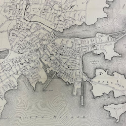
One of the busiest spots in Massachusetts during the month of October is the city of Salem! And though the crowds, traffic, and parking might make it difficult to visit this time of year, you can check it out through our displayed collection item. Visit us this month to see “City of Salem” a 1916 map that is part of our Special Collections holdings.


The map was published by the Walker Lithograph and Publishing Company, which was located at 400 Newbury Street in downtown Boston. Though this map is just an individual page, you might notice the page numbers “34” and “35” printed in the top left and right corners. That is because this map was originally part of the Atlas of Massachusetts, which was compiled under the direction of O.W. Walker, with assistance from more than one hundred civil engineers and surveyors. In addition to the individual map on display this month, our library holdings also include the full atlas, which has been digitized and can be accessed here. In the preface, Walker writes, “The information it [the atlas] contains represents a vast amount of labor, the design being to represent as many of the important features and locations as possible without giving the maps a crowded appearance.” And as the library’s preservation librarian, I appreciate that the preface also includes this notation, “the paper was made especially for this purpose by one of the acknowledged leaders in that great industry. It is a Bond paper that will be found adapted to resist reasonable use for many years. The bindings are all neat and substantial.” You can read the full preface and explore all of the towns and cities in the atlas by clicking on the link above.

And now for a closer look at the map itself, which shows the boundary lines of Salem as it appeared in 1916. The map lays out the city’s streets and provides street names, along with identifying buildings like schools, city hall, the county jail, the Custom House, and the railroad station. Extending into Salem harbor are the city’s wharves and even a designation for Derby Wharf Light Station. But one of the more prominent features on the map is the illustration of Salem Common, which dates to Salem’s earliest European settlement in the 1620s. Salem was first settled by Europeans in 1626, making it the second oldest settlement in the state, and colonized in 1628. Before Europeans arrived, the land was known as Naumkeag and inhabited by Indigenous people of the Massachusetts Tribe. From Salem’s Pioneer Village website, we learned that in 1626, “Naumkeag homes (known as wigwams) were discovered “abandoned” due to seasonal travel by the indigenous population, and the English took them over for their own dwellings.” Read more about Naumkeag and the people who originally lived there on the Pioneer Village website. When Salem was inhabited by European settlers, Salem Common was established as an area to be collectively used (hence the name “common”) for animal grazing. It became a more established park in the early 1800s and was added to the National Register of Historic Places in 1976.

Visit us through November 1 to see this map on display and check out all of the nooks and crannies of Salem that you might want to explore once the October crowds wind down. And while you are visiting us, be sure to check out another case in our library that shares books on the spookier side of Salem!


Elizabeth Roscio
Preservation Librarian


Tuesday, September 5, 2023

On Display in the State Library

From kindergarten to college, students in the Commonwealth are heading back to school! With that in mind, this month we're sharing two circulars associated with public schools in Dorchester in the 1800s – visit us to see “Rules and Regulations to be observed by the Teachers of the Public Schools in Dorchester” (1810) and “Order of Exercises at the Dedication of the Building and Installation of the Teacher of the High School” (Dorchester, 1852).

Dorchester was annexed into Boston in 1870, but when these two circulars were issued it was a separate town that had been founded in 1630. Its educational history dates to that period, too – the Mather School, which is the oldest public elementary school in North America, was established in Dorchester in 1639. The school was named after Richard Mather, a Congregational minister who had emigrated to Dorchester from England in 1635. The original Mather School was a one-room schoolhouse, and though the building has changed over the years, the Mather School is still in existence as an elementary school serving students in grades K through 5.

171 years after the founding of the Mather School, the displayed circular (above) was issued to teachers in Dorchester’s public schools. The notice is divided into ten rules or guidelines, with a notation that it was “first passed on August 26, 1805; with amendments and additions, June 27, 1810.” The regulations include instruction to begin the day with a devotional, which books are recommended for each grade, the school schedule, relationship between the School Master and School Committee, and how to assess if children are ready for school, as follows:

Children are not to be admitted to the Schools, till, they are able to stand up, and read words of two syllables, and keep their places."

On the back of the circular is a handwritten notation of “Mr. Lemuel Crane” and “5 School District,” who we assume was recipient of this notice. A brief search of Lemuel Crane revealed an entry in the Hyde Park Historical Register on the Butler School, which was founded in 1786 and listed a Lemuel Crane as assisting with the endeavor. Since Hyde Park was part of Dorchester at the time, we can speculate that this was the same Lemuel Crane who received the public school circular. The article went on to say that Lemuel Crane also served as a Representative for the 5th District in the General Court. You can read the full article on the Hyde Park Historical Society’s website (pages 9-12).

Jumping forward in time, we are also displaying a circular from the dedication of Dorchester High School, which occurred on December 7, 1852. The program for the dedication was as follows: remarks from the Chairman of the Building Committee, a reply and address by the Chairman of the School Committee, a prayer, a hymn sung by the pupils, an address to the pupils, a poem, another hymn sung by the pupils, and finally an introduction of the teacher followed by remarks from the teacher. That sounds like a long program, so we hope that there were also some refreshments on hand for the attendees! Take a close look at the image to see the content of the two hymns.

Last year, we marked the beginning of the school year by displaying the rules and regulations for Quincy Public Schools, published in 1835. You can read about that circular, and the textbooks that were displayed alongside it, here. And be sure to visit us through September 28 to see these Dorchester circulars on display in our main reading room. Happy back to school!


Elizabeth Roscio
Preservation Librarian

Monday, July 31, 2023

On Display at the State Library

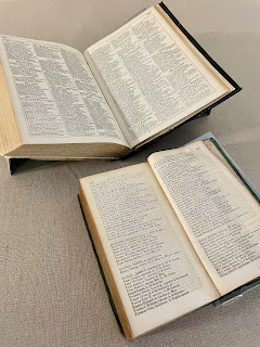
In honor of August's designation as National Black Business Month, we're highlighting John P. Coburn, a Black Bostonian and business owner who lived just around the corner from the State House on Beacon Hill in the mid-1800s. On display in our reading room are a selection of Boston city directories showing Coburn’s home and business listings, and a facsimile of an advertisement for his business that was published in the abolitionist newspaper The Liberator in 1845.

John P. Coburn was a well-known clothier in Boston with two business locations, one on Brattle Street and one on Cornhill (today’s City Hall Plaza). Coburn was a free Black resident of Boston, born in the early 1800s. Between 1843 and 1844, he commissioned architect Asher Benjamin to design his home at 2 Phillips Street on Beacon Hill, where he lived until his death in 1873. The historic John Coburn House is now a private residence and not open to the public, but it is part of the Black Heritage Trail walking tour within the Boston African American National Historic Site. Beyond being a successful businessman with a stately home on Beacon Hill, there is much more to John Coburn’s story. He was also a community activist involved with the Boston Vigilance Committee and the New England Freedom Association, both organizations that aided those who had escaped from slavery. And he was a founder of the Massasoit Guards, which was an all-black militia whose purpose was to protect residents from slave catchers. You can read more about Coburn on the National Park Service’s webpage.

On display are Boston city directories from 1845 and 1850/1851. The 1845 directory is open to the page showing Coburn’s home address and the 1850/1851 directory is displayed showing his business listing. In the 1845 directory, Coburn is listed in the section designated for people of color. A few years later, the 1848/1849 directory would be the last one that would segregate residents by race, and from 1850 onward, all residents were listed in a single alphabetical order. In the 1845 residential listing, Coburn is shown as a clothes dealer at 51 Cornhill, with a house listing on Southac (Southac is the former name of Phillips Street). In the 1850/1851 business directory, Coburn is listed as one of the businesses under the “clothing - second hand” heading, with a location of 24 Brattle. If you are curious about other city and town directories in our collection, you can access the full list of our holdings here.

We’re also displaying a facsimile of an advertisement for John Coburn’s clothing business, as published in the January 31, 1845 issue of The Liberator. The facsimile is provided courtesy of the Digital Commonwealth but here at the State Library, we have a run of The Liberator available on microfilm, as well as a bound volume of issues dating from 1861 to 1865. The Liberator was an weekly abolitionist newspaper published by William Lloyd Garrison and Isaac Knapp. In this advertisement, Coburn informs “abolitionists and friends in general” that his business has changed locations from 8 Brattle Street to 51 Cornhill and 24 Brattle Street. The advertisement goes on to list the services that he provides, including buying off-cast clothing (the 19th century version of thrifting!) and cleaning and mending garments at short notice.

John Coburn advertisement in The Liberator
Courtesy of the Digital Commonwealth

Visit us throughout the month to see these items on display and be sure to keep an eye out for resources in your own area promoting Black Business Month!


Elizabeth Roscio
Preservation Librarian

Monday, July 3, 2023

On Display in the State Library

Massachusetts is home to a number of great libraries and has been for many years! But do you know just how many libraries were functioning in Massachusetts in the late 1800s? Visit us throughout this month to find out! We’re displaying Free Public Libraries of Massachusetts, a map designed and hand-drawn by George Hartnell Bartlett in 1893.

While we were closed to the public in 2021, we shared a 1904 version of this map in our “virtual display case.” You can read more about that version and about Bartlett himself here. The version that we’re displaying this month differs a bit in design. Instead of drawings of each library, this map is much more number focused. In this version, each city or town is identified along with a number signifying its population. If the town includes a library, then a little book is drawn, and within that book is a number that shows how many volumes are included in its library. For example, Worcester has a population size of 84,656 and a volume size of 89,268 - enough for each person in the city to check out a book at the same time, and then still have almost 5,000 left on the shelves! The map also gives some state-wide figures and shows that in 1893 there were 352 cities and towns in Massachusetts and 300 of them had free public libraries. In 1892, the number of volumes circulated for home use throughout the Commonwealth was 5,040,629 – that’s pretty impressive considering that the population of Massachusetts at the time of the 1890 census was 2,228,943!

We typically try to highlight a collection item that has some sort of seasonal connection, and at first glance this might not seem like a likely contender for July, a time when in the past we’ve shared more blatantly patriotic items like our newspaper copy of the Declaration of Independence, our broadside version of the Declaration of Independence, a 1849 program of 4th of July events and an 1890 photograph of the State House adorned in bunting. But this map is, in fact, a timely collection item because it speaks to the role that libraries play in supporting our democratic society. Massachusetts is home to the first and longest continuously running public lending library. The town of Franklin was incorporated in 1790 and was named after Benjamin Franklin. When it was suggested that Franklin donate a bell for the meeting house tower, he instead donated a small collection of books. This collection went on to become the foundation of the first circulating library in the country, accessible to all citizens in the town, and is still currently housed at the Franklin Public Library. Of the donation over books instead of a bell, Franklin was said to have stated that “sense” was preferable to “sound.” And as Thomas Jefferson, author of the Declaration of Independence, is quoted as saying, “an educated citizenry is a vital requisite for our survival as a free people." Both quotes support the statement that libraries are a cornerstone of our democracy. Libraries give citizens the opportunity to establish and engage in an informed discourse, which is at the foundation of a free society. Circulating collections, database access, public programming, and research assistance are just some of the ways that librarians strive to provide all citizens, regardless of race, religious affiliation, age, gender, with safe access to resources and services that promote education, well-being, and engagement.

From the first circulating library in 1790, to the publication of this map in 1893, to today, libraries have been hubs of resources for those seeking knowledge. Check out the American Library Association’s Bill of Rights to see the policies that libraries abide by to ensure that they continue to be forums for information for all. And stop by the library throughout the month to see the map of Commonwealth libraries on display! If you can’t visit us in person, click on the image above or explore a high-resolution copy available through the Norman B. Leventhal Map Center at the Boston Public Library.


Elizabeth Roscio
Preservation Librarian