
Monday, December 25, 2023
Season's Greetings from the State Library
From the State Library to you, our digital greeting card wishing you a wonderful holiday season and a happy New Year!

Monday, December 18, 2023
Books As Gifts are Always a Hit

Chester A. Baker.
Christmas 1909.
From S.J.B.
Shaggycoat is one of many children’s nature books written by blind naturalist Clarence Hawkes, who was known for writing Black Bruin: The Biography of a Bear, and Shovelhorns: The Biography of a Moose. Hawkes primarily wrote about wildlife in New England and was highly regarded for his scientifically accurate descriptions of animals in nature. Hawkes attended Perkins School for the Blind, having lost his sight in a hunting accident when he was 13 years old. According to the Perkins Archives Blog, Hawkes became friends with Helen Keller. Keller felt Hawkes was unmatched in his writings on nature and praised his colorful, captivating narrations of life in the great outdoors.

It is easy to see why Shaggycoat made for an excellent children’s Christmas present at the turn of the century. We here at the State Library feel that the holiday season is still the perfect time to gift loved ones, both young and old, the joy of reading. We wish you warm, safe, and happy holidays, hopefully curled up beside a fire with a good book!
Work consulted:
Coit, Susanna. “Patience, perseverance, and pluck: Clarence Hawkes, the blind naturalist.” Perkins Archives Blog, Perkins School for the Blind, Watertown MA. June 19, 2020.
Alyssa Persson
Special Collections Processing Librarian
Work consulted:
Coit, Susanna. “Patience, perseverance, and pluck: Clarence Hawkes, the blind naturalist.” Perkins Archives Blog, Perkins School for the Blind, Watertown MA. June 19, 2020.
Alyssa Persson
Special Collections Processing Librarian
Monday, December 11, 2023
Santa, Lighthouses, and Airplanes: New England’s Flying Santa Tradition
One of my favorite things about working at the State Library is coming across a fun historical fact or story that I had never heard before, while working on something completely unrelated. A few weeks before Halloween I was looking for a book about New England legends in the stacks and came across a book with an eye-catching cover. I flipped through it and while it didn’t have any information I was looking for, I did come across a picture of Santa and an airplane and it made me wonder what the two had in common (this was Santa with an airplane after all, and not a team of reindeer). I took the book back to my desk and started reading and discovered a fun New England story I had never heard about before. If you’re like I was and don’t know the story behind Flying Santa, this blog post is for you!
 |
| Image courtesy of Friends of the Flying Santa |
The Flying Santa tradition began in 1929 during a harsh winter storm. An airplane pilot caught in the storm used lighthouse beacons along Maine's Penobscot Bay to fly home to safety. The pilot’s name was William Wincapaw of Friendship, ME. To show his thanks to the lighthouse keepers, he dropped packages filled with treats for their families as he flew over the lighthouses. Throughout that year, Wincapaw would get stuck in other storms and the lighthouse keepers would keep an eye out for him, letting airfield know when he had safely passed over their lighthouses. Wincapaw and later his son, Bill Jr., kept this joyous tradition going each year and expanded their Flying Santa trips to also cover Massachusetts, Rhode Island, and Connecticut. The Wincapaws moved to Winthrop, MA in 1933 and by that point, their Flying Santa routes brought them to 91 lighthouses and Coast Guard stations in New England.
Edward Rowe Snow came into the world of the Flying Santa only a few years later. He was born in Winthrop, MA in 1902, and stayed in Winthrop where he became a high school history teacher. In 1936, Rowe Snow, who knew Bill Jr., joined the Wincapaws to assist them with their continuously-expanding Flying Santa program. That first year he covered the 25 southern routes with Bill Jr. flying, while Bill Sr. flew the northern routes.
The Flying Santa tradition was carried on by Rowe Snow until 1980. What’s important to note is that Mr. Snow was not a pilot. After the Wincapaws could no longer take part in the tradition, Mr. Snow had to hire a pilot and a plane for the lighthouse flights. He kept this beloved New England tradition going despite the obstacles that stood in his way and despite the funds that he had to contribute to keep Flying Santa alive. After Snow’s Flying Santa days were behind him due to old age, the tradition was kept alive through the work of the Hull Lifesaving Museum and its members, and later with the help of WCVB-TV 5. By 1997, the Flying Santa tradition had expanded so much that it had outgrown the museum. A group of volunteers got together to form the non-profit educational group called Friends of the Flying Santa, Inc. Over the next decade and beyond, many people stepped in to help the Friends keep Santa flying through the New England skies each holiday season.
Be sure to read much more about the history and evolution of this program on the Friends of the Flying Santa website. The full story of this tradition is rich with detail and the Friends have shared lots of photos on their website as well. You can also learn more about this tradition from the New England Historical Society.
Thank you to the Friends of the Flying Santa for the work they did to document the history of this tradition. It’s a tradition that still lives on today! December 2023 marks the 94th year of the Flying Santa! You can see photos and videos from last year’s flight here. Keep an eye out for photos from this year as well--Flying Santa made a stop at the Hull Lifesaving Museum on Saturday, December 9th!
 |
| William Wincapaw, Sr. (left) and William Wincapaw, Jr. (right) Images courtesy of Friends of the Flying Santa |
Edward Rowe Snow came into the world of the Flying Santa only a few years later. He was born in Winthrop, MA in 1902, and stayed in Winthrop where he became a high school history teacher. In 1936, Rowe Snow, who knew Bill Jr., joined the Wincapaws to assist them with their continuously-expanding Flying Santa program. That first year he covered the 25 southern routes with Bill Jr. flying, while Bill Sr. flew the northern routes.
 |
| Image from The Lighthouses of New England, 1716-1973, by Edward Rowe Snow |
 |
| Image from The Lighthouses of New England, 1716-1973, by Edward Rowe Snow |
Be sure to read much more about the history and evolution of this program on the Friends of the Flying Santa website. The full story of this tradition is rich with detail and the Friends have shared lots of photos on their website as well. You can also learn more about this tradition from the New England Historical Society.
 |
| Flying Santa in 2022, the tradition's 93rd year. Image courtesy of WCVB. |
Thank you to the Friends of the Flying Santa for the work they did to document the history of this tradition. It’s a tradition that still lives on today! December 2023 marks the 94th year of the Flying Santa! You can see photos and videos from last year’s flight here. Keep an eye out for photos from this year as well--Flying Santa made a stop at the Hull Lifesaving Museum on Saturday, December 9th!
Jessica Shrey
Reference Librarian
Thursday, December 7, 2023
Two Pairs of Two Turtle Doves in the Library!

The two sets of turtle doves are depicted looking pretty cozy in the branches of the Stuartia tree, which Audubon wrote symbolized purity and chastity. In the bottom scene, the female sits in the nest while the male tends to her, and in the top scene, the female is perched on the edge of the branch with the male reaching out to her. The turtle dove is also known as the mourning dove, and in the past was referred to as the Carolina turtle dove or Carolina pigeon, which is how Audubon referred to the bird when he depicted it in the 1830s. Read more about the turtle dove here and here, and also check out their entry in the Guide to North American Birds.
Elizabeth Roscio
Preservation Librarian
Monday, December 4, 2023
On Display in the State Library
Prior to 1939, the Commonwealth included four towns that are now no longer in existence: Dana, Enfield, Greenwich, and Prescott. This past September, we were excited to mount a new exhibit outside of the library, “The Four Lost Towns of the Quabbin Reservoir,” which shared information and period documents about these towns and the sacrifices that they made so that the Commonwealth could develop the Quabbin Reservoir. This month, we are excited to welcome author Elena Palladino to speak on her recent book Lost Towns of the Swift River Valley: Drowned by the Quabbin. To complement both the new exhibit and our upcoming Author Talk, this month in our Collection Spotlight case, we are displaying two historical maps that depict the Commonwealth before and after the development of the Quabbin Reservoir.
 In our Collection Spotlight case, we are sharing two maps of the Commonwealth, one from 1902 and one from 1939, which was just after the completion of the Quabbin. The 1902 map is the simply titled “Map of Massachusetts,” and was published by George H. Walker & Company, a prolific publisher of lithographs located in Boston. To the left of center of the map, and also highlighted in the image here, you will see the boundary lines for Dana, Enfield, Greenwich, and Prescott, all grouped together. Of note is the train track that is shown running through the towns and labeled as the B&A - this is the Athol branch of the Boston and Albany Railroad. The majority of this branch was closed in the 1930s when construction of the reservoir began. The map also identifies post offices and money order post offices, of which there are a few located within these towns. Even this small designation on the map emphasizes that these were active communities that people lived and worked in before they were destroyed, thirty-seven years after the publication of this map. The 1939 map is titled “Commonwealth of Massachusetts, Department of Public Health: showing location of cities and towns and health districts.” Though the reservoir is not actually shown in this map, if you look in the circled portion in the map above, you will see that Enfield, Greenwich, Dana, and Prescott are not shown and that the nearby towns of Belchertown, Pelham, New Salem, Petersham, Hardwick, and Ware have grown in size. That is because any land of the four lost towns that remained after the development of the reservoir were then incorporated into the surrounding municipalities.
 |
| 1902 map is shown on the left and 1939 map is shown on the right |
As my colleague wrote in the exhibit’s introduction panel, “In 1938, the towns of Greenwich, Dana, Enfield, and Prescott were disincorporated, evacuated, and flooded to accommodate the construction of the Quabbin Reservoir. Centrally located in the Swift River Valley, the Quabbin was constructed as the solution to providing drinking water to the state’s metropolitan areas. To facilitate this plan, the legislature created the Metropolitan District Water Supply Commission in 1926 (Act Chapter 375). The MDWSC undertook the project, overseeing the creation of the reservoir and flooding of the Swift River Valley. In addition to the four towns, villages and parts of other towns were also taken by the state for the project. It was the first time the legislature had to disincorporate a whole town. Per 1938 Act Chapter 240, the four towns would cease to exist in Massachusetts.” Read more about each of these towns in the online version of the exhibit.

While these maps will only be on display through January 4, you can visit us to view the Quabbin exhibit through September 2024. We are open Monday through Friday from 9:00 to 5:00 and the online version of the exhibit is available anytime! More information about our upcoming Author Talk on Lost Towns of the Swift River Valley is available here; we hope that you'll be able to join us on December 6, but if you are unable to make it, a recording will be uploaded to our YouTube page a few days following the event.
Elizabeth Roscio
Preservation Librarian
Friday, December 1, 2023
State Library Newsletter - December Issue
Happy December! Our monthly newsletter is out today, and is full of information about our online store, upcoming events, exhibited items, and more!
Pictured here is a preview, but the full issue can be accessed by clicking here. And you can also sign up for our mailing list to receive the newsletter straight to your inbox.
Monday, November 27, 2023
Author Talk with Elena Palladino
![]()
- Lost Towns of the Swift River Valley: Drowned by the Quabbin
- Wednesday, December 6, 2023. 12pm - 1:00pm
- State Library of Massachusetts - Room 341, Massachusetts State House
- Livestream: https://www.youtube.com/user/mastatelib
.jpg)
Please join us on Wednesday, December 6th at noon, in our historic reading room to hear Elena Palladino speak on her 2022 book, Lost Towns of the Swift River Valley: Drowned by the Quabbin. For anyone who cannot make it into the library, we will be livestreaming the talk on our YouTube channel, courtesy of the Massachusetts House of Representatives Broadcast Services.
About the book: In 1938, four Massachusetts towns were disincorporated, evacuated, and flooded to accommodate the construction of the Quabbin Reservoir. The reservoir was the solution to providing Boston and the State’s metropolitan areas with fresh drinking water. In Lost Towns of the Swift River Valley, Palladino tells the story of Dana, Enfield, Greenwich, and Prescott, the towns which were sacrificed to make room for the Quabbin. Through archival research, Palladino recounts the history of these communities through three townspeople of the Swift River Valley: Marion Smith, a woman from a wealthy manufacturing family, William Segur, the country doctor, and Edwin Howe, postmaster and general store owner. Palladino brings life and feeling to these communities that once were thriving and home to many.
 About the author: Elena Palladino is a Massachusetts native, growing up in Sturbridge and now residing in Ware. Palladino’s family lives in Marion Smith’s former home, which sparked her interest in the history of the Quabbin. Palladino holds a BA degree in English from Simmons College, an MA in literary and cultural studies from Carnegie Mellon University and an EdM in higher education from Harvard University. She currently works in higher education in Western Massachusetts and also sits on the board of directors for the Swift River Valley Historical Society and Friends of Quabbin. For more on Palladino and her “Quabbin House” visit this page.
If you are able to join us in person for this talk, attendees will be able to participate in a question-and-answer session with the author as well as purchase a copy of the book for $24.00 (payments can be made via Venmo or cash). As always, this author talk is free and open to all. Assisted listening devices will be made available upon request. Any questions or concerns, please email us.
 In
addition, now on display is the State Library’s new annual exhibit: The Four Lost Towns of the Quabbin
Reservoir. We invite you to visit the library (room 341 of the State House)
to view the exhibit and learn more about the towns of Dana, Enfield, Greenwich,
and Prescott. A few highlights of the exhibit include Prescott’s last Annual
Town Report, a picture from Greenwich’s last town meeting, and documents from
the Metropolitan District Water Supply Commission, the state agency responsible
for the reservoir. The State Library is open Monday - Friday, 9-5, and the full
exhibit is also available to view on Flickr!
In
addition, now on display is the State Library’s new annual exhibit: The Four Lost Towns of the Quabbin
Reservoir. We invite you to visit the library (room 341 of the State House)
to view the exhibit and learn more about the towns of Dana, Enfield, Greenwich,
and Prescott. A few highlights of the exhibit include Prescott’s last Annual
Town Report, a picture from Greenwich’s last town meeting, and documents from
the Metropolitan District Water Supply Commission, the state agency responsible
for the reservoir. The State Library is open Monday - Friday, 9-5, and the full
exhibit is also available to view on Flickr!

If you are able to join us in person for this talk, attendees will be able to participate in a question-and-answer session with the author as well as purchase a copy of the book for $24.00 (payments can be made via Venmo or cash). As always, this author talk is free and open to all. Assisted listening devices will be made available upon request. Any questions or concerns, please email us.

Author Talks Working Group
Monday, November 20, 2023
Celebrate with a Grateful Heart

In November 2019 we displayed our Proclamation for a Day of Thanksgiving and Prayer that was issued by Governor John Hancock on November 8, 1783. Printed as a broadside and distributed throughout the Commonwealth to notify citizens of the upcoming observance, this document established Thursday, December 11 as a day for all Massachusetts residents to devote themselves to prayer and giving thanks. It also was issued to commemorate the official ending of the Revolutionary War. Though this 18th-century day of Thanksgiving is different from the holiday that we celebrate today, the proclamation urges citizens to “assemble to celebrate with grateful hearts and united voices,” a sentiment that continues today, much as it did well over two hundred years ago. Read more about this historic proclamation in our previous blog post.
This 1783 proclamation is just one of many in our Special Collections holdings. You can see images of our oldest proclamation from 1779 and a 1796 proclamation issued by Governor Samuel Adams in another past blog post. Our collection includes 112 Thanksgiving Day proclamations that have been digitized and uploaded to our online repository. They date from 1779 to 1903 with continuity, and then there are a few more recent ones issued by Governor Baker. If Governor Healey issues a proclamation, it will also be added to our collection! Explore the full collection of proclamations here, using keyword "Thanksgiving."
A reminder that the library will be closed this upcoming Thursday and to those who celebrate, we wish you a happy Thanksgiving!
Elizabeth Roscio
Preservation Librarian
Monday, November 13, 2023
’Tis the Season for Cranberries!
 |
| Image courtesy of A complete manual for
the cultivation of the cranberry |
 |
| Image courtesy of A complete manual for the cultivation of the cranberry |
Cape Cod Cranberry Growers Association (CCCGA), established in 1888, is one of the nation’s oldest farmer’s associations. According to their website, cranberry cultivation began in 1816. Revolutionary War veteran Captain Henry Hall from Dennis, Massachusetts, had wild cranberry bogs and noticed that the berries grew better when sand from the Cape Cod dunes blew over them. Captain Hall then began transplanting cranberry vines and spreading sand on them to spark their growth. The sand not only helps the vines grow, but also slows the growth of insects and weeds. Word spread about the technique Hall discovered and it was adopted by the increasing number of growers throughout the 1800s. Today, cranberry growers spread one or two inches of sand on their cranberry bogs every three years. As time has gone on, the cranberry has adapted to change and the modern world, just like its name. Earl Mills Sr, Flying Chief Eagle of the Mashpee Wampanoags, said that in many ways, “the history of this indigenous fruit mirrors that of the native people.”
 |
| Images courtesy of A complete manual for the cultivation of the cranberry |
 |
| Image courtesy of Cape Cod Cranberry Growers Association |
For more information about cranberries, including a timeline of major events related to cranberry history, check out the CCCGA’s website. Be sure to read our previous blog post on cranberries as well--it’s full of “berry” good information!
Works and websites consulted:
- A complete manual for the cultivation of the cranberry : with a description of the best varieties, by Benjamin Eastwood, 1856
- Cape Cod Wampanoag Cookbook : Wampanoag Indian Recipes, Images & Lore, by Earl Mills Sr. and Betty Breen, 2001
- Cranberries: The Berry of Massachusetts, State Library blog post, 2020
- Cape Cod Cranberry Growers Association
- UMASS Amherst Center for Agriculture, Food, and the Environment
Jessica Shrey
Reference Librarian
Thursday, November 9, 2023
The Great Blue Heron Glides into the Library

Since November is Native American Heritage Month, we're displaying an Audubon print that has significance to the Indigenous community. The Great Blue Heron (plate 211) will be on display in the library through December 7. The Great Blue Heron is an adaptable water bird that resides in both fresh and salt water - specifically marshes, swamps, shores, and tide flats. It feeds mostly by walking slowly or standing still in shallow water, as depicted here. You might also spot one gliding high above. The adult male is shown in this print, but the female looks very similar. You can read more about the Great Blue Heron in the Audubon Field Guide.
For members of the Mashpee Wampanoag Tribe, who inhabit Massachusetts and Eastern Rhode Island, the Great Blue Heron represents patience, balance, and accuracy. Read a homage to this stately water bird in a past issue of Mittark, the monthly newsletter of the Mashpee Wampanoag Tribe.
Elizabeth Roscio
Preservation Librarian
Monday, November 6, 2023
Author Talk with Representative Josh S. Cutler
- The Boston Gentlemen's Mob: Maria Chapman and the Abolition Riot of 1835
- Wednesday, November 15, 2023. 12pm - 1:00pm
- State Library of Massachusetts - Room 341, Massachusetts State House
- Livestream: https://www.youtube.com/user/mastatelib

Please join us on Wednesday, November 15th at noon, in our historic reading room to hear Representative Cutler speak on his 2021 book, The Boston Gentlemen's Mob: Maria Chapman and the Abolition Riot of 1835. Representative Cutler serves the Sixth Plymouth District which includes the towns of Duxbury, Halifax, Hanson, Marshfield, and Pembroke.
For anyone who cannot make it into the library, we will be livestreaming the talk on our YouTube channel, courtesy of the Massachusetts House of Representatives Broadcast Services. The recording of the talk will also be made available on our YouTube channel post-event to enjoy at your convenience.
About the book: The Boston Gentlemen's Mob focuses on the events of October 21, 1835 in the city of Boston. As the anti-slavery movement grew, so did the tension between businessmen and abolitionists. On October 21, 1835, a riot broke out in the streets of Boston. Enraged businessmen, merchants, and bankers disrupted a women’s abolitionist meeting and an angry mob soon formed. The group would eventually set their sights on William Lloyd Garrison, publisher of The Liberator - the period’s leading abolitionist newspaper. Garrison was trapped, caught, and left to the mercy of the mob. Cutler recounts this day in history from four different perspectives: Maria Chapman, an abolitionist; Susan Paul, a school teacher; Theodore Lyman, Boston’s Mayor; and Wendell Phillips, attorney and spectator of the day’s events. The Boston Gentlemen's Mob is an exciting read that highlights the early days and struggles of the anti-slavery movement.

If you are able to join us in person for this talk, attendees will be able to participate in a question-and-answer session with the author, and Rep. Cutler will sign and sell copies of The Boston Gentlemen's Mob, with 100% of proceeds being donated to the State Library. As always, this author talk is free and open to all. Assisted listening devices will be made available upon request. Any questions or concerns, please email us.
Want to stay up to date on future Author Talks at the State Library? Join our mailing list. Also follow us on Instagram, Facebook, or X for updates! For more information on the State Library Author talks series, please visit our site.
Author Talks Working Group
On Display in the State Library - Corn, Squash, and Beans

Three Sisters planting is a type of companion planting where each crop sustains the others. The corn stalks provide a tall stake for beans to climb so they don’t get snarled in squash vines, and the beans in turn provide extra support for the stalks. Beans also provide nutrients in their roots that fertilizes soil, and squash leaves provide shade and retain moisture. And in addition to this symbiotic relationship, the vegetables also complement each other and add to a nutritious diet. Squash, beans, and corn are a major component of Native American dishes, and though the origins of Three Sisters planting is attributed to the Iroquois, many Native American communities throughout North America employed it, including the Wampanoag and the Nipmuc here in the northeast. You can read more about Three Sisters planting on these sites. And from our own collection, you can read The Nipmuc Story of the Three Sisters (story 8) in Stories and Poems for Northeastern Native Tribal Families.

- The New American Gardener: Containing Practical Directions on the Culture of Fruits and Vegetables; Including Landscape and Ornamental Gardening, Grape-Vines, Silk, Strawberries by Thomas Green Fessenden, and published by J.B. Russell in Boston in 1828. The book is displayed open to the entry on squash and includes a note that “the squash is applicable to all the uses of the pumpkin, and for many purposes, is superior to that vegetable.” Winter squash is a more mature squash, and its hardened rind means that it can be stored and consumed well into the colder months. This was especially useful for Indigenous communities and settlers in the northeast, who after a bountiful harvest, would continue to have squash in their diet throughout the winter.
- The Cultivator's Almanac, and Cabinet of Agricultural Knowledge, for the year 1841 compiled by William Buckminster and published in Boston by H.B. Williams in 1841; and A Treatise on Cobbett’s Corn: Containing Instructions for Propagating and Cultivating the Plant, and for Harvesting and Preserving the Crop by William Cobbett and published in London by Mills, Jowett, and Mills in 1828. These two sources are displayed to highlight corn: Cobbett’s Corn shows an illustration of a corn stalk (shown above), and The Cultivator’s Almanac is opened to the November page, writing that “the harvesting of corn is pretty work, and much of it may be done by moonlight; or in cold weather, by candle light. When placed in a convenient floor way, a number of hands will sit very happily for three hours in an evening, and separate the corn from the husks.” The almanac also includes a notation on November’s Thanksgiving holiday, writing that “this festival usually happens on the last week in this month, and all the fall work should be finished before its arrival.” Even among these three important crops, corn stands above. It's a versatile vegetable that could be eaten raw, roasted, baked into other foods, or dried and then ground into cornmeal. Its a lynchpin of the Native American diet, and consequently, it became a key component of the English settlers' diet when they arrived in North America, too.
- The New-England Farmer or Georgical Dictionary: Containing a Compendious Account of the Ways and Methods in Which the Important Art of Husbandry, in All Its Various Branches, Is, or May Be, Practised, to the Greatest Advantage, in This Country by Samuel Deane and published by Isaiah Thomas in Worcester in 1797. This dictionary is displayed open to the section on beans, and it describes the different varieties of beans found in New England, along with the notation that "there is no danger of their being hurt by a small degree of frost, should it happen to come early." When planting the Three Sisters crops, it was recommended that the corn is planted first and then the beans two to three weeks later.
Visit the library through December 1 to see these agricultural sources on display. And if you're looking to get outside after your Thanksgiving meal (which may include squash, beans, and/or corn!) you can explore the Three Sisters Trail in Milford!
Elizabeth Roscio
Preservation Librarian
Thursday, November 2, 2023
State Library Newsletter - November Issue
With a new month, comes a new newsletter! From displayed items, upcoming events, and new books on the shelf, find out everything that's happening this November at the State Library.

Pictured here is a preview, but the full issue can be accessed by clicking here. And you can also sign up for our mailing list to receive the newsletter straight to your inbox.

Monday, October 30, 2023
Happy Halloween!
Happy Halloween from the State Library! Enjoy these creepy-crawly finds from the collection.
 |
| COMMON SPIDERS, 1902 |
 |
| SPIDERS: THEIR STRUCTURE AND HABITS, 1890 |
Looking for more spooky reads? Check out the titles below!


For more thrillers, check out Libby! State Employees can use their State Library card credentials to download Libby, the library reading app. Sign-up for a library card today! Did you miss last week’s Author Talk on the Salem Village Witch Trials? You can view author Daniel Gagnon’s recorded discussion of his biography on Rebecca Nurse on our YouTube channel!
Happy Halloween and happy reading!
April Pascucci
Legislative Reference Librarian
Monday, October 23, 2023
Reading Recommendations from the Browsing Collection
Located in the entry hall into the Newspaper and Periodical Room (Room 442), we have a new collection of nonfiction and fiction titles for library visitors to browse.
Here are some books from the Browsing Collection you may enjoy reading during October whether you like to read mystery, horror, or nonfiction:
I Will Find You by Harlan Coben
Do you happen to be a fan of Liam Neeson and the Taken film series? Then you’d probably like reading I Will Find You. David Burroughs is a man wrongfully accused of murdering his young son, Matthew. Six years later, while serving his prison sentence, David finds out that his son may still be alive. He hatches a plan to escape prison so he can find his now 9-year-old son. With the FBI in hot pursuit after his escape, will he succeed in rescuing his son? And will he be able to clear his name?
Verity by Colleen Hoover
 Having a hard time choosing between a romance book and a horror book? Why not read something that is both? Lowen Ashleigh, an aspiring novelist, is struggling to make ends meet as a ghostwriter. She is offered a well-paying gig after witnessing a fatal accident and being guided into a coffee shop by a kindly stranger. The kindly stranger happens to be Jeremy Crawford, the husband of famed author Verity Crawford. He asks Lowen to finish his wife’s series of best-selling novels since her health prevents her from completing them. After they bond over recent losses in the coffee shop—Lowen over the loss of her mother and Jeremy over the loss of his twin daughters—Lowen decides to accept the job offer. While going through Verity’s manuscripts of partially written novels, she makes a chilling discovery about Verity. As Lowen spends time at the Crawford home in Vermont, she wonders if she should tell Jeremy the truth as she falls for him.
Remarkably Bright Creatures by Shelby Van Pelt
If you are more of a cozy mystery fan rather than a thriller or horror reader, this book is for you. A mystery set at an aquarium in Puget Sound where an elderly janitor named Tova forms a friendship with Marcellus, a Giant Pacific Octopus, after saving his life. The novel is partially narrated from the perspective of the curmudgeonly Marcellus, who decides to find out the truth about the death of Tova’s son, Erik, 30 years prior. The tentacled gumshoe finds a way to communicate with Tova as he uncovers the truth behind Erik’s tragic death and something that will impact Tova’s future.

Emily Crawford
Technical Services Librarian
Here are some books from the Browsing Collection you may enjoy reading during October whether you like to read mystery, horror, or nonfiction:
I Will Find You by Harlan Coben
Do you happen to be a fan of Liam Neeson and the Taken film series? Then you’d probably like reading I Will Find You. David Burroughs is a man wrongfully accused of murdering his young son, Matthew. Six years later, while serving his prison sentence, David finds out that his son may still be alive. He hatches a plan to escape prison so he can find his now 9-year-old son. With the FBI in hot pursuit after his escape, will he succeed in rescuing his son? And will he be able to clear his name?
Verity by Colleen Hoover

Remarkably Bright Creatures by Shelby Van Pelt
If you are more of a cozy mystery fan rather than a thriller or horror reader, this book is for you. A mystery set at an aquarium in Puget Sound where an elderly janitor named Tova forms a friendship with Marcellus, a Giant Pacific Octopus, after saving his life. The novel is partially narrated from the perspective of the curmudgeonly Marcellus, who decides to find out the truth about the death of Tova’s son, Erik, 30 years prior. The tentacled gumshoe finds a way to communicate with Tova as he uncovers the truth behind Erik’s tragic death and something that will impact Tova’s future.
The Wager: A Tale of Shipwreck, Mutiny and Murder by David Grann

A mesmerizing, suspenseful nonfiction book about the wrecking of the H.M.S. Wager in 1741 off the coast of Chile and the mutiny that soon followed. David Grann draws from a treasure chest of primary sources– diaries, letters, logbooks and more--to construct a lively historical narrative. Two separate groups of survivors from the wreckage arrived in Brazil in 1742, each with a different version of events. Accusations of treacherous behavior and murder culminated in a court martial to uncover the truth. Whichever party was found guilty of mutiny and murder would hang.
Technical Services Librarian
Monday, October 16, 2023
Author Talk with Daniel Gagnon
- A Salem Witch: The Trial, Execution, and Exoneration of Rebecca Nurse
- Wednesday, October 25, 2023. 12pm - 1:00pm
- State Library of Massachusetts - Room 341, Massachusetts State House
- Livestream: https://www.youtube.com/user/mastatelibrary
 The State Library of Massachusetts Author Talks Series is excited to host author Daniel Gagnon on October 25th for a seasonally appropriate talk on the Salem Witch Trials.
Please join us on Wednesday, October 25th at noon, in our historic reading room to hear Daniel Gagnon speak on his 2021 book, A Salem Witch: The Trial, Execution, and Exoneration of Rebecca Nurse. For anyone who cannot make it into the library, we will be livestreaming the talk on our YouTube channel, courtesy of the Massachusetts House of Representatives Broadcast Services. The recording of the talk will also be made available on our YouTube channel post-event to enjoy at your convenience this spooky season!
About the book: A Salem Witch: The Trial, Execution, and Exoneration of Rebecca Nurse is the first complete biography of Rebecca Nurse. In 1692, the inhabitants of Salem Village entered a period of hysteria and fear as accusations of witchcraft spread. Rebecca Nurse was one of the accused. Nurse, an elderly, well-respected member of the community was put on trial and eventually executed despite the support and protests from her family and neighbors. Daniel Gagnon expertly uses primary research to give readers the full account of Nurse’s life and gives a new perspective on the witch trials in today’s view.

If you are able to join us in person for this talk, attendees will be able to participate in a question-and-answer session with the author as well as purchase a copy of A Salem Witch. As always, this author talk is free and open to all. Assisted listening devices will be made available upon request. Any questions or concerns, please email us at AuthorTalks.StateLibrary@mass.gov.
Want to stay up to date on future Author Talks at the State Library? Join our mailing list. Also follow us on Instagram, Facebook, or X for the latest updates! For more information on the State Library Author Talks Series, please visit our site: https://www.mass.gov/state-library-author-talk-series.
Author Talks Working Group
Thursday, October 12, 2023
Caw caw! There are crows in the library!

Scarecrows, which are designed to look like humans, are placed in fields to protect crops from crows and other birds. The use of scarecrows dates back to antiquity, though nowadays they tend to pop up most frequently this time of year as Halloween or autumnal décor. When a scarecrow is in use and a crow is deterred from pilfering corn, it also eats acorns, berries, and seeds, along with small rodents, crayfish, and insects. You can read more in the Audubon Field Guide.
Elizabeth Roscio
Preservation Librarian
Monday, October 9, 2023
The Story of William Blackstone, Boston, and the Apple in North America
Happy fall, everyone! As a New England resident, one of my favorite fall treats to enjoy is a crisp apple from one of our many local apple orchards. Nothing says “fall in New England” more than a freshly picked apple (other than a pumpkin spiced latte of course). Do you know the history of the apple in the United States though? Today we’ll tell you the story of Reverend William Blackstone (or Blaxton) and how he brought the apple to this country.
 |
| Image courtesy of Boston Magazine |
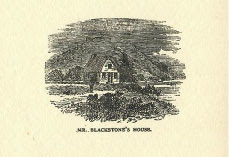
Blackstone, born in Lincolnshire, England around 1595, was an early colonial settler with an interesting story. His mother passed away when he was a young boy. In 1621, he was ordained by the Church of England and then lost his father not long after. Left alone in England without parents, he heard of the Plymouth and Jamestown settlements and decided to make his way across the ocean for a new life, along with his collection of books. He arrived in what is now Weymouth, MA in 1623. The Weymouth settlement didn’t last long, and in 1625 the other settlers who had been with him traveled back to England. Blackstone, however, moved north to present-day Beacon Hill in Boston and lived there by himself for five years on the Shawmut Peninsula, becoming the first European settler in Boston.
 |
| Image from Rev. William Blackstone, the Pioneer of Boston |
In 1629, Isaac Johnson, one of Backstone’s fellow students from Emmanuel College (Cambridge), and the Puritans landed in nearby present-day Charlestown. The land was rocky there, making it difficult to tap wells. Knowing the difficulties they were facing, Blackstone wrote a letter to Johnson, letting them know about the natural spring on the land that he was living on and invited them to settle there. On September 7, 1630, the Puritans took Blackstone up on his offer, leaving Charlestown and settling on the land Blackstone was living on. Only a couple weeks later, on September 30, 1630, Johnson died and as his last act as the leader of the Charlestown community, he named the new settlement “Boston", after his hometown of Boston, Lincolnshire. Eventually the number of settlers grew in Boston and Blackstone decided to sell his parcel of land to the city. That land became a town common, where cattle were free to graze. Today, this land makes up most of Boston Common. It was on today’s Boston Common land where Blackstone planted the first apple seeds in the colonies. Historians also credit him with the nation’s first apple orchard, which grew in Boston Common sometime in the 1620s.
 |
| Image from William Blackstone, Boston's first inhabitant |
Upon leaving Boston in 1635, Blackstone moved to present-day Cumberland, Rhode Island a year before Roger Williams arrived. He married at 64 years old and had a son a year later. On May 26, 1675, Blackstone died in Cumberland, RI, where he had settled 40 years earlier. Today you can visit the Founders Memorial in Boston Common, which shows Blackstone greeting John Winthrop and inviting him and his group to the Shawmut Peninsula. You can also visit Blackstone’s grave in Cumberland.
 |
| Image courtesy of Digital Commonwealth via Boston Public Library |
Blackstone came to America and, as author Thomas Amory wrote of him, “here he dwelt, solitary and alone, raising apples and roses, and reading his books, of which he had a plentiful supply.” He was an interesting figure in history and if you’d like to learn more about him, feel free to reach out to us at reference.department@mass.gov and/or look through some of the resources below.
Works consulted and other articles of interest:
- William Blackstone, Boston’s first inhabitant by Thomas Amory, 1877
- William Blackstone in his relation to Massachusetts and Rhode Island… by B.F. DeCosta, 1880
- Rev. William Blackstone, the Pioneer of Boston by John C. Crane, 1896
- William Blackstone, the “First Settler” of Boston and Rhode Island by John Williams Haley, 1958
- An Intensive A-to-Z Guide to Apples, New England’s Most Iconic Fall Fruit by Boston Magazine, 2023
Jessica Shrey
Reference Librarian
Subscribe to:
Posts (Atom)