One of the busiest spots in Massachusetts during the month of October is the city of Salem! And though the crowds, traffic, and parking might make it difficult to visit this time of year, you can check it out through our displayed collection item. Visit us this month to see “City of Salem” a 1916 map that is part of our Special Collections holdings.
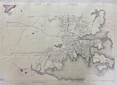
The map was published by the Walker Lithograph and Publishing Company, which was located at 400 Newbury Street in downtown Boston. Though this map is just an individual page, you might notice the page numbers “34” and “35” printed in the top left and right corners. That is because this map was originally part of the
Atlas of Massachusetts, which was compiled under the direction of O.W. Walker, with assistance from more than one hundred civil engineers and surveyors. In addition to the individual map on display this month, our library holdings also include the full atlas, which has been digitized and can be accessed
here. In the preface, Walker writes, “The information it [the atlas] contains represents a vast amount of labor, the design being to represent as many of the important features and locations as possible without giving the maps a crowded appearance.” And as the library’s preservation librarian, I appreciate that the preface also includes this notation, “the paper was made especially for this purpose by one of the acknowledged leaders in that great industry. It is a Bond paper that will be found adapted to resist reasonable use for many years. The bindings are all neat and substantial.” You can read the full preface and explore all of the towns and cities in the atlas by clicking on the link above.
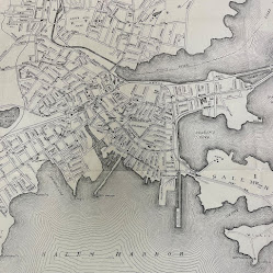
And now for a closer look at the map itself, which shows the boundary lines of Salem as it appeared in 1916. The map lays out the city’s streets and provides street names, along with identifying buildings like schools, city hall, the county jail, the Custom House, and the railroad station. Extending into Salem harbor are the city’s wharves and even a designation for Derby Wharf Light Station. But one of the more prominent features on the map is the illustration of Salem Common, which dates to Salem’s earliest European settlement in the 1620s. Salem was first settled by Europeans in 1626, making it the second oldest settlement in the state, and colonized in 1628. Before Europeans arrived, the land was known as Naumkeag and inhabited by Indigenous people of the Massachusetts Tribe. From Salem’s Pioneer Village website, we learned that in 1626, “Naumkeag homes (known as wigwams) were discovered “abandoned” due to seasonal travel by the indigenous population, and the English took them over for their own dwellings.” Read more about Naumkeag and the people who originally lived there on the Pioneer Village
website. When Salem was inhabited by European settlers, Salem Common was established as an area to be collectively used (hence the name “common”) for animal grazing. It became a more established park in the early 1800s and was added to the National Register of Historic Places in 1976.
Visit us through November 1 to see this map on display and check out all of the nooks and crannies of Salem that you might want to explore once the October crowds wind down. And while you are visiting us, be sure to check out another case in our library that shares books on the spookier side of Salem!
Elizabeth Roscio
Preservation Librarian

