Showing posts with label FY2022 monthly exhibit. Show all posts

Tuesday, May 31, 2022

On Display in the State Library

June 17th marks 247 years since the Battle of Bunker Hill in Charlestown, one of the earlier battles of the Revolutionary War. To mark the anniversary, this month we’re exhibiting “A plan of the Action at Bunkers Hill on the 17th of June 1775 between His Majesty's troops, under the Command of Major General Howe, and the American Forces.” This map is a 1793 facsimile of an original from 1775. 

The map was originally prepared by Sir Thomas Hyde Page, who was a British military engineer and cartographer. He was sent with a corps of engineers to America and served under Sir Robert Page. At Bunker Hill, he acted as aide de camp to General William Howe, who was in command of the British forces for that operation. During the battle, Page was severely wounded and lost his leg, and was evacuated back to England. During his recovery, he drew maps of various conflicts in Boston, including the one on display here. The map is an accurate and detailed depiction of the battle, done by someone who was there. You can read more about Page on this page.

Our version of this map is not a 1775 original, which was published soon after the battle and has a slightly different title, referring to the “American Forces” as the “Rebel Forces.” Our version was published in 1793 in London as part of The History of the Origin, Progress, and Termination of the American War by Charles Stedman. If you visit us and look closely at the display, you’ll see that the map is actually in two pieces, showing where it was removed from a bound book. The 1793 version also differs from the original by including a reference to the plan, which identifies key movements of the military forces. The map depicts hedgerows, redoubts (a temporary fortification), the placement of British and American forces, and lines of fire from ships in the Charles River and a section of Boston that we now know as the North End. 

In the center of the map is a noticeable illustration labeled “Warren’s redoubt,” which was constructed at the top of the hill. “Warren'' refers to Joseph Warren, who was a member of the Sons of Liberty, a physician, the 2nd President of the Massachusetts Provincial Congress, and as of a few days before the battle, a commissioned major general in the Massachusetts militia. This spot on the map references where he was killed when British troops stormed the redoubt. Warren, who chose to engage in battle as a private rather than staying a safe distance away as his rank would allow, was honored in death as a martyr for the patriot cause. The British did win the battle by taking the hill, but their casualty losses were higher than expected and the colonial militia was not as easily defeated as expected.

Visit the main library’s reading room throughout the month to see this map on display, or click here to see the digitized version in the collection of the Leventhal Map Center at the Boston Public Library. And if you’d like to read more about Joseph Warren, check out Founding Martyr: The Life and Death of Dr. Joseph Warren, the American Revolution’s Lost Hero by Christian Di Spigna.


By Elizabeth Roscio
Preservation Librarian

Monday, May 2, 2022

On Display in the State Library

May is Asian American and Pacific Islander Heritage Month, so as we were preparing to change the item in our monthly display case we wanted to select something from our collection that would align with that designation. On exhibit throughout the month of May are the 1930 and the 1931 Chinese Directory of New England, published by Hop Yuen Company at 14 Oxford Street in Boston, which was also the home of the United Chinese Association. 

Asian American and Pacific Islander Heritage Month began as just a ten-day long celebration in early May of 1978 before it was expanded by Congress in 1992 so that it would last the entire month. According to a Census.gov website, the week was initially established to “coincide with two important milestones in Asian/Pacific American history: the arrival in the United States of the first Japanese immigrants (May 7, 1843) and contributions of Chinese workers to the building of the transcontinental railroad completed May 10, 1869.” Asian immigrants arrived in Boston and New England a little bit later than that, the City of Boston has recorded that the first influx of Chinese immigrants were single men who arrived in 1873 to work in a factory in North Adams. By the time these directories were published nearly fifty years later, the Chinese population in New England had greatly increased.

The New England directories in our collection date to 1930 and 1931, and both are on display in our main library reading room. The directories list Chinese owned businesses by category for each New England state, along with many advertisements, a few of which are pictured below. The bulk of the advertisements are for Chinese owned businesses, like the one below left that features two restaurants in Boston’s Chinatown. But there are also a fair amount for non-Chinese owned businesses, like the one below right. Freeman O. Emerson (general insurance) and Dublin Brothers (cigars and tobacco) both took out ads in the directory and wrote about their services in Chinese to reach new audiences. The advertisements for non-Chinese owned businesses written in Chinese show that business owners acknowledged the importance of New England’s Chinese residents as a vital part of the community and economy. 


 In addition to the bi-lingual business listings and advertisements, the directories also included welcome letters by the Massachusetts Governor, Lieutenant Governor, and Boston Mayor, along with essays on immigration and trade, and a list of Chinese students enrolled at the Massachusetts Institute of Technology and Harvard. In the 1931 directory, the letter from Boston Mayor James Curley was addressed to Mr. Wong C. Poy, and a search of his name lead us to a Boston Globe article published on May 5, 1931 about the publication of this directory. The article identifies Mr. Poy as a prominent Chinatown merchant and as the compiler behind this directory. We can assume that he wrote the preface, which explains the impetus behind this directory as follows, “for the past few years, the ever-growing Chinese population in this section of the country has been demanding a concise and complete directory of their nationals in New England” and that “practically every city or town of any importance, within the confines of New England, numbers among its merchants, a Chinese laundry, restaurant, or store.” The need for a directory of this nature, which both served as a valuable resource for Chinese residents and helped non-Chinese business reach a Chinese audience that might have otherwise been unattainable, highlights the role that Chinese Americans played in New England in the early 20th-century as their population grew in size. 

Visit the library this month to see these directories in person and learn more about Asian American and Pacific Islander Heritage Month here.


Elizabeth Roscio
Preservation Librarian

Monday, April 4, 2022

On Display in the State Library

With its warming temperatures and sprouting blooms, April has been designated by the National Garden Bureau as National Garden Month. To mark this month-long celebration of spring, currently on display in the library’s reading room is a nearly 300-year-old text that would serve as a useful reference for every gardener. Visit us to see volume one of The Gardeners Dictionary: Containing the Best and Newest Methods of Cultivating and Improving the Kitchen, Fruit, Flower Garden, and Nursery by Philip Miller and published in London in 1759. 

The Gardeners Dictionary was an often-cited reference source compiled by botanist Philip Miller (1691-1771). According to the description on the title page, Miller was “gardener to the worshipful company of apothecaries, at their botanic garden in Chelsea, and member of the Botanick Academy at Florence.” Miller served as the head gardener at the Chelsea Physic Garden (also known as the Apothecaries’ Garden) in London from 1722 until his retirement in 1770. Through the publishing of his dictionary, he is also regarded as one of the top horticultural writers of the eighteenth century. One could say that his profession ran in his blood, as his father was a gardener, and his two sons were also botanists. 

The two-volume set in the State Library’s collection is the seventh edition, which as noted on the title page was “revised and altered according to the latest system of botany; and embellished with several copper-plates, which were not in the former editions.” In total, there were eight editions published during Miller’s lifetime, with the first edition dating to 1731. These volumes are incredibly comprehensive, as indicated by the full title: The Gardeners Dictionary: Containing the best and newest methods of cultivating and improving the kitchen, fruit, flower garden, and nursery, as also for performing the practical parts of agriculture: including the management of vineyards, with the methods of making and preserving the wine, according to the present practice of the most skilful vignerons in the several wine countries in Europe. Together with directions for propagating and improving, for real practice and experience, all sorts of timber trees. Within the pages are an explanation of technical terms, a listing of the other works and authors that Miller consulted for this publication, and some drawings. But the bulk of the book is an alphabetical listing of plants, along with descriptive information, origin and varieties, and care instructions. While the version in our collection has not been digitized, you can access the full text of the dictionary through the Bibliothèque Nationale de France.

We have displayed the book open to its frontispiece and title page. The frontispiece is a beautiful drawing depicting Nature, Industry, Britannia, and Science. Britannia is shown being presented with a cornucopia of fruits and flowers. All the figures are gathered in front of an orangery, which was a structure found on wealthy estates in the 1600s to the 1800s. Orangeries were large buildings that kept orange and other fruit trees protected during the winter months. Below the drawing is a line of Latin that reads, “Behold, the boys bring baskets to you full of flowers.”

Whether you are an avid gardener yourself or just appreciate the beauty that others cultivate, we hope you’ll mark National Garden Month by stopping by the State Library to take a look at The Gardeners Dictionary!


Elizabeth Roscio
Preservation Librarian

Monday, February 28, 2022

Currently on Display in the State Library

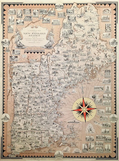
This month, we’re excited to remind you that you can now visit the library and view our featured collection item in person! Currently on display in the State Library’s reading room is A Pictorial Map of the New England States, U.S.A. by renowned cartographer Ernest Dudley Chase. Dating to 1939, it is an illustrated map of the six states that comprise New England: Connecticut, Rhode Island, Massachusetts, New Hampshire, Maine, and Vermont.

Read about this map in our previous blog post, and then visit us to check out all its intricate details in person. The State Library is open to the public Monday through Friday from 9:00 to 5:00. The public can access the State House through the Ashburton entrance and be sure to check the requirements for entry before you visit. 

For those of you who can’t visit us, we’d also like to share a few of the other Ernest Dudley Chase maps found in our Special Collections.

Above left is France as drawn by Ernest Dudley Chase in 1935. This map has a fleur de lis border and shows an illustration for each French town. Paris has an illustration of the Eiffel Tower, the Arc de Triomphe and Notre Dame. There are also illustrations of landmarks flanking the map. And above right is The United States as viewed by California (very unofficial). A California-centric map “distorted and drawn” by Ernest Dudley Chase in 1940. It shows planes, trains, cars, and buses speeding across the rest of the country on the way to California, and we appreciate the annotation for New England that it is “kissed by the sun part of the time. After all, many Californians, or their forbears, came from this section.”

And lastly, published by the Massachusetts Department of Commerce and Development in 1956 is Historic Massachusetts, a travel map to help you feel at home in the Bay State. The map identifies Massachusetts as “a world of fun and relaxation” and it includes illustrations of the state’s landmarks and activities, along with an inset of Greater Boston. A useful tool for any tourist!


We’ll be changing the library’s display case at the beginning of each month, so stay tuned to see what other items will be exhibited in the months to come. And as always, we’ll continue to share the featured item through our blog and social media for those who can only visit us remotely.


Elizabeth Roscio
Preservation Librarian

Monday, January 31, 2022

On (Virtual) Display in the State Library

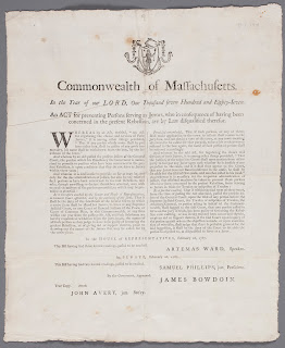
This month, our featured collection item is a broadside dating to February 1787 and issued by the Massachusetts General Court while James Bowdoin was governor. Titled in part as “An Act for Preventing Persons Serving as Jurors, Who in Consequence of Having Been Concerned in the Present Rebellion, Are by Law Disqualified Therefor,” the broadside addresses some consequences for those who participated in Shays’ Rebellion, which concluded earlier in the month that this Act was passed. 

James Bowdoin was elected as governor in May 1785, following John Hancock’s resignation partway through his term. Once in office, Bowdoin worked to collect back taxes, which Hancock had been reluctant to actively pursue while governor. But in a depressed post-Revolutionary War economy, Bowdoin made it a priority to both raise taxes and collect back taxes in an effort to raise funds for the state’s portion of foreign debt payments to European war investors. This was met by protest from those in the central and western parts of the state who were struggling financially since they had not been paid for their wartime service. Individuals now found themselves having to pay high taxes that they could not afford, or risk losing their livelihood, a situation that caused unrest and ultimately led to what we now know of as Shays’ Rebellion. 

This month marks 235 years since the conclusion of Shays’ Rebellion, which was an armed uprising that occurred in western Massachusetts beginning in the summer of 1786. Residents of the area organized protests in response to the fact that the legislature had adjourned without addressing their concerns about taxation. From August to October, groups of protesters successfully forced the closure of courts in Northampton, Worcester, Great Barrington, Concord, and Taunton. In January 1787, led in part by Daniel Shays, groups of protesters organized in an attempt to overtake an armory in Springfield. They were met by a militia organized by Gov. Bowdoin, which consisted primarily of individuals from the eastern part of the state. Clashes continued from the end of January into early February, before the protesters’ forces fell apart and many participants fled north.

The broadside in our collection was Issued by the General Court in the weeks after Shays’ Rebellion. The Act printed on it stated that anyone who favored the rebellion, or gave aid or support to the rebellion, was prohibited from serving as a juror for three years. Selectmen from the towns in which the participants resided were instructed to remove their names from the jury-boxes (from which names would be drawn to serve as jurors). Earlier in February, the legislature also passed the Disqualification Act, which disqualified any known participant in the rebellion to serve in some elected or appointed positions. There is a lot more to the economic climate leading to Shays’ Rebellion, the rebellion itself, and its aftermath than we can address in this blog post. To learn more, check your local library for books like  Shays's Rebellion: Authority and Distress in Post-Revolutionary America by Sean Condon and Shay’s Rebellion: The American Revolution's Final Battle by Leonard L. Richards.

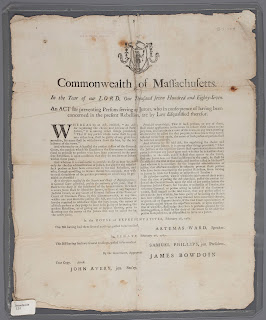
And lastly, a note on the condition of this broadside, since it looks pretty good for having been printed 235 years ago! We do a lot of collection repair and preservation work in-house, but we send items out to the Northeast Document Conservation Center (NEDCC) for more involved work. In 2018, this broadside was one of a few that underwent treatment at NEDCC. It was removed from its plastic enclosure and then cleaned to reduce staining, discoloration, and acidity. It was also humidified so the edges could be uncurled and creases reduced, and then any tears and losses were mended with thin Japanese paper and wheat starch. Check out the image to the right to see how it looked before treatment and compare that with the “after” photo featured at the beginning of this post! 

Elizabeth Roscio
Preservation Librarian


Monday, January 3, 2022

On (Virtual) Display at the State Library

“Happy New Year! I wish you a happy new year!” Is the kind of greeting among friends on the first of this month, the commencement of a new year.” 

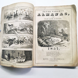
The introductory note in Peter Parley's Almanac for Old and Young, published in 1837, starts off with this festive quote. Following in the footsteps of years prior, we’re starting the year by sharing an historical almanac from our collection. Peter Parley was the pseudonym for Samuel Griswold Goodrich, a 19th-century author, publisher, and bookseller who also served as a member of the Massachusetts State Senate and House of Representatives. 

The contents of an almanac do not typically seem like the sort of publication that would appeal to a younger audience, but that is one way that Peter Parley’s differs from other almanacs. In addition to providing the sort of lunar charts and weather predictions found in most almanacs, this almanac includes a few extra details that makes it more accessible to younger readers. The title page shows the New Year chasing the Old Year into the woods, while Time looks on, and there are whimsical drawings for each month. We’ve included January here, complete with snowy hills and horse drawn carriages. Each month is also accompanied by two pages of text that describes nature (specifically birds and plants) to observe and activities to undertake. We especially liked this excerpt from January’s outdoor activities that describes the best way to construct a snowman:

Select from the wood-pile a forked stick, long enough for a full grown giant, say eight or ten feet; fix it upright with the forked end downwards. This is to answer for the skeleton; which you are to load with snow instead of muscles and sinews. Build up the figure with masses of snow to the shoulders of top of the stick, and here fix two sticks of a proper length for arms: cover these also with snow, and on top of all, place a huge snowball for the head. To enable you to reach high enough, you can roll up a large snowball or two, to stand upon. When you have added snow enough, with a shovel, shingle, or garden trowel, you can fashion the figure according to fancy, giving it a hat, a nose, mouth, &c., with eye-brows and a beard of moss, and a pipe to smoke if you like, by placing a long slender stick in his mouth, and coating it with snow.

The bulk of the almanac contains descriptions for each month, but the last twenty pages are comprised of “Varieties from my pocket-book” a collection of information that is described by Peter Parley as, “I have a habit of putting scraps that please me into my pocket-book. Among the collection that I have thus been making I find the following.” Included is everything from instructions to make hard water soft to an analysis of the meaning of the phrase “there is time enough” with random items like a list of things a farmer should not do in between. It is a miscellaneous listing of items with topics that are sure to appeal to readers of all ages! 

The copy in our collection has not been digitized, but we found a digital version available through Tufts University. Their version is identical to ours, except that it was printed in New York at Freeman Hunt & Co. and our version was printed right in Boston at Otis, Broaders & Co. on Washington Street. The last page of the Tufts version has been torn, so it is missing the last entries in Parley’s pocket-book. And if you want to kick off your year with even more almanac content, but sure to check out our post from 2020 on Isaiah Thomas’s New England Almanac and our 2021 post on Fleet's Pocket Almanack for the year of our Lord 1789: Being the First after Leap Year and the Thirteenth of American Independence. Happy New Year!


Elizabeth Roscio
Preservation Librarian

Monday, November 29, 2021

On Display in the State Library

This month, our featured collection item is a fun map found in our Special Collections holdings. A Pictorial Map of the New England States, U.S.A. is by renowned cartographer Ernest Dudley Chase and dates to 1939. It shows, in great detail, the six states that comprise New England: Connecticut, Rhode Island, Massachusetts, New Hampshire, Maine, and Vermont.

If you were looking for a topographical map of New England, or a map that would show you how to get from point A to point B, you may want to look elsewhere. But this map is an excellent example of an illustrated map, which takes a more artistic, and less technical approach to cartography. Towns and cities are identified within each state and are accompanied by a drawing of an important building or landmark associated with that location. New England’s many lighthouses dot the coastline and various sailing vessels are found in the Atlantic. A fun aspect of this map is that sprinkled throughout it are illustrations of activities that can be enjoyed in that area; take a close look to see drawings of ice fishing at Sebago Lake in Maine, sunbathing at Falmouth on Cape Cod, and skiing in Gorham, Vermont. These are just a few examples, what other drawings do you spot within the map? Additionally, along the outer edges of the map are slightly larger drawings of important buildings with a title identifying their name and location, and found on the perimeter of the map, distinguishable by oval frames, are drawings of each state’s capital building - including our very own State House. 

Detail image of Cape Cod, Massachusetts
Ernest Dudley Chase was a prolific illustrator and cartographer from the early to mid-1900s. The State Library holds several of his maps in our collection, and we hope to have them all available digitally in the future, but for now a full list of our Chase holdings can be found here. As you can see, his maps were not limited to New England, but include world maps, other locations within the United States, European countries, and themed maps. 

For a high-resolution version of this New England map, please click here to explore the copy in Harvard’s map collection. There is a lot of detail to be found on this map, each time you look at it you can find something new! Zoom in on this digital version to see all of the intricate drawings - buildings, activities, landmarks - that make New England such a special place to live or visit.


Elizabeth Roscio
Preservation Librarian


Monday, November 1, 2021

On (Virtual) Display at the State Library

We might be biased, but we think one of the prettiest views in Boston is looking up from the Common to the State House. So this month, we’re sharing a lithograph of just that view in our virtual display case. Boston Common was drawn by James Kidder and published by Abel Bowen in Boston in 1829. It shows the State House and its neighbors atop Beacon Hill, with a swath of the Common in the foreground. Adults and children are shown strolling paths, cows graze on the grass, and young trees are shown in growing supports, all of which combine to create a bucolic scene in the middle of downtown Boston. 

A noticeable feature in this lithograph is that the State House is a much smaller building than its current size. This image shows the original building as designed by Charles Bulfinch and completed in 1798. A large addition, designed by Charles Brigham, was added to the back of the State House between 1885 and 1889, and the east and west wings, designed by architects Sturgis, Bryant, Chapman & Andrews, were added between 1914 and 1917. Though not visible from this exterior image, the State Library itself, which was established in 1826, would have been found within the walls of this 1829 State House, but not in the same location it occupies today. Visit the Flickr album from our past exhibit on the history of the State Library to learn more about the library’s location at its 1826 founding, its expansion and move in 1856, and the move to its current location in 1895. Just as the State House has grown over the years, so has the State Library!

While the State House dominates the view in this lithograph, there are a few other buildings of note visible. If you are facing the State House from the Common, as this view shows, the building that is visible to its right is the Amory-Ticknor House, located at 9-10 Park Street and 22-22A Beacon Street.  This is a Federal style mansion designed by Charles Bulfinch and built in 1804. Soon after its construction, however, the building’s owner Thomas Amory sold it and it was enlarged and divided into multiple dwellings (which is why it has door fronts on both Park and Beacon Streets). The rest of the building’s name comes from a later owner, scholar George Ticknor, who resided in the building at the same time that this lithograph was published. He lived in the building until 1871, followed by his daughter, Anna Eliot Ticknor, who lived in the building until 1884. After that, the building was used for retail rather than dwellings and has housed restaurants, coffee shops, and stores ever since. Over the years, the Amory-Ticknor house has seen some alterations, most noticeably, the addition of oriel windows on the upper levels, but the house still stands today. 

And to the left of the State House is another important building, but unfortunately, one that has not survived to the present day. The Hancock Manor was located at 30 Beacon Street, in fact, not far from where our Special Collections Department is located today. It was built in the 1730s for the merchant Thomas Hancock and his wife Lydia, who were John Hancock’s aunt and uncle. The stately mansion sat among outbuildings, gardens, orchards, and pastures - much different from the Beacon Hill that we know of today. John Hancock lived in the house after the death of his aunt and uncle, and it was after his death in 1795 that some of the pasture land was purchased by the Commonwealth to be used as the site of the future State House. For a number of years afterward, the State House and the Hancock Manor were neighbors until the mansion was demolished in 1863. Before it was torn down, relics and souvenirs were retrieved from the house, so even though it doesn’t live on in its entirety, pieces of the mansion can still be found in historical collections throughout Massachusetts and beyond.  

To take a closer look at the State House and its neighbors, click on the image above. And the next time you visit Boston Common, imagine what it looked like in 1829! 


Elizabeth Roscio
Preservation Librarian


Monday, October 4, 2021

On (Virtual) Display at the State Library

As the calendar turns to October, we’re featuring an item related to one of the month’s unofficial mascots - cats! A quirky little pamphlet called Murthy’s Cattage: A Biographical Dictionary of Cats in Literature is this month’s item in our virtual display case. Inside the pamphlet, the reader will find a list of cats associated with literature and authors. Each entry includes a biographical note, which sometimes includes a physical description or breed like Tabby, or Maltese, or one of October’s favorite symbols - black cats!  

Murthy’s Cattage was compiled by Howard Millar Chapin and was published in Providence, Rhode Island in 1911. The pamphlet is dedicated to the memory of Chapin’s own cat, and the namesake of the book, Murthy, a picture of whom appears on the first pages. Within the pamphlet is an alphabetical listing of cats, and according to an introductory note at the beginning of the list, “this work is a brief biographical dictionary of cats in literature, that is of cats mentioned in literature or owned by literary or historical personages.” Many of the literary references and authors named in the dictionary might be unfamiliar to today’s readers but examining the list reveals some familiar names. There’s Chanoine, who belonged to Victor Hugo; Sour-Mash, who belonged to Mark Twain; and Puss-in-Boots, the folklore hero of a familiar nursery tale. 

National Black Cat Day is October 27 so we searched the list for a few black cats that were the well-loved pets of some nineteenth century authors. There’s Lucifer, who was the pet of Harriet Prescott Spofford, a New England author who published extensively from the 1850s into the 1920s. Spofford wrote newspaper serials, novels, detective stories, and poems. Gavroche and Eponine, both black cats, were the pets of French author Théophile Gautier (and named soon after the publication of Victor Hugo’s Les Miserables). Gautier loved cats so much that a carving of one is included on his headstone in Paris. And Dixie, who was the subject of Dixie Kitten by Eva March Tappen. Tappen was a Massachusetts resident and a graduate of Vassar College, who went on to be a teacher and a children’s book author. She was also the owner of Dixie’s kitten, and fellow black cat, Topsy. 

Beyond the introductory note and the alphabetical listing of cats, there’s no other information in this brief pamphlet, though we would be interested in reading about how Howard Millar Chapin selected cats for this list, how he found some of the biographical information, or how he traced the lineage of some of the cats included. A search of the title and the author’s name did reveal some interesting details about him, though. Murthy’s Cattage was just one of many books by Chapin (and might be one of his most whimsical topics); he also wrote at length about Rhode Island’s history and American colonial history. He served as the Librarian of the Rhode Island Historical Society from 1912 until 1940. His papers are held in the RIHS collection and the finding aid can be accessed here

Murthy’s Cattage is a brief pamphlet of less than a dozen pages, and it can be accessed in DSpace here. Even though not all the references found in the dictionary are immediately recognizable, it is still worth a read through for the cat descriptions. And it also serves as a bit of a literary time capsule, by highlighting authors and titles that might not be as well-known today as they were when this pamphlet was published in 1911. See what new cats you might find when you take a look at Murthy’s Cattage

Elizabeth Roscio
Preservation Librarian

Monday, August 30, 2021

On (Virtual) Display at the State Library

It goes without saying that we’re big fans of all the Commonwealth’s many libraries, so we’re happy to share this map, Public Libraries of Massachusetts, as our September featured collection item. September is Library Card Sign-Up Month, designated as such by the American Library Association. It’s a great time to visit your local branch, which might be depicted on this map, and see what wonders you can experience with a library card!

Published in 1904, this map of the Commonwealth’s libraries was designed and drawn with pen and ink by George Hartnell Bartlett. It shows the boundary lines for each town, and each town that includes a library also has a small but intricate drawing of said library. A larger drawing at the bottom of the map shows the Boston Public Library, along with circulation and volume statistics.  Bartlett created other versions of this map in both 1893 and 1914.

The Massachusetts Board of Library Commissioners shared this map in 2015 as part of a timeline celebrating 125 years of service. On the timeline, they cite a reference to the map in the Fifteenth Report of the Free Public Library Commission, which we have available in DSpace. The report states, “The skilful [sic] hand of Prof. George H. Bartlett, principal of the Normal Art School, prepared for the Louisiana Purchase Exposition a large map of the State, containing pen and ink drawings of over 250 of our library buildings in the towns they serve. This map attracted great attention during the continuance of the fair at St. Louis, and will form a portion of the State exhibit at the coming Lewis and Clarke [sic] Exposition. It was awarded the grand prize at St. Louis. A reduced copy of the map forms a portion of this report.” The map was included as a folded insert at the beginning of the report, but the copy in our collection has been removed from the report so that it could be flattened and stored in a separate enclosure. From a preservation standpoint, we recommend removing folded inserts so that they don’t wear, and potentially tear, along crease lines.  

In the report mentioned above, George Hartnell Bartlett is referenced as principal of the Normal Art School, which was the original name of what is now known as the Massachusetts College of Art and Design. The Normal Art School was founded in 1873 and is the oldest art school in the country. In addition to serving as an art instructor and drawing maps, Bartlett was also the author of Pen and Ink Drawing: A Series Of Drawings Showing Its Perfect Adaptability To The Modern Processes Of Reproduction, a copy of which can be found in our Special Collections holdings. 

For a closer look at the map, you can click on the above image. And for an even closer examination, a high-resolution copy of this map can be found through the Boston Public Library’s Leventhal Map Center. Click around to find the library from your own hometown or from a neighboring town. It is interesting to see what each library retains of its original elements, and to compare how they have grown and changed over the years. 


Elizabeth Roscio
Preservation Librarian

Monday, August 2, 2021

On (Virtual) Display at the State Library

Take a trip to the coast of the North Shore with this month’s virtually displayed collection item! We’re featuring a bird’s-eye view map of the small village of Magnolia, which is located in Gloucester, Massachusetts right over the town line from Manchester-by-the-Sea. 

This item was specifically selected for virtual display during the summer months because from the mid-1800s and into the 1900s Magnolia was a vacation destination for Bostonians and other New England and New York residents. This map was published in 1887, so it depicts Magnolia in its relatively early days of development. The legend in the bottom right of the map identifies some of the town's landmarks. Unfortunately, our copy has experienced some paper loss, so the full legend isn’t available. However, the Boston Public Library’s Leventhal Map Center also has a copy, which includes the full legend.

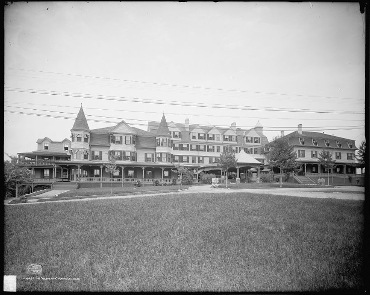
Detroit Publishing Co., Copyright Claimant, and Publisher
Detroit Publishing Co. The Hesperus, Magnolia, Mass.
United States Massachusetts Gloucester, ca. 1906. Photograph.
From the legend, we know that stately homes and sprawling resorts were found in Magnolia in 1887. The largest structures that dominate the map are located near the center right off the town green. They are identified as the Oceanside Hotel (D) and The Hesperus (E). Neither hotel is still in existence, but at the time, they were posh retreats for vacationers looking to escape the city and be near the sea. 

We’d also like to point out one inconspicuous building in the far-reaches of the map. A long rectangular building labeled “M” is shown in the distance off of Normans Avenue - that building is a bowling alley! The first indoor bowling alley in the United States opened in New York in 1840, and by the late 1800s, they were popular meeting (and drinking) spaces for men. Bowling alleys were more often frequented by working-class men, possibly after a long day of working in the resorts and businesses that catered to wealthy out-of-towners. A check of a contemporary map of Magnolia showed that while there are many more roads there now than there were in 1887, and some of the streets have changed names, Norman Avenue (identified as Normans Ave. in 1887) is still in existence - there isn’t evidence of a bowling alley on that site, though. 

In addition to buildings and roads, there are always a lot of fun details to see in bird’s-eye view maps, like different modes of transportation and people engaged in various activities. Take a closer look at life in Magnolia by clicking on the above image or checking out its record on DSpace. And while you’re in DSpace, be sure to peruse our full collection of digitized bird’s-eye view maps.


Elizabeth Roscio
Preservation Librarian

Monday, June 28, 2021

On (Virtual) Display at the State Library

This July, towns across the Commonwealth are preparing for Fourth of July celebrations. On that theme, this month our virtually displayed item is a broadside titled “Historical Celebration” that dates to 1849 and described the activities that were planned for the town of Leicester on July 4, 1849.

The broadside lists the “order of exercises” for the celebration, starting with music by the band. This was followed by a prayer by Rev. J. Nelson, D.D., a hymn by Henry S. Washburn, Esq., and an address by Hon. E. Washburn. A dinner was held at the conclusion of the event. There isn’t much additional information provided on the broadside, but a little bit of research led us to “An address commemorative of the part taken by the inhabitants of the original town of Leicester, in the events of the Revolution: delivered at Leicester, July 4, 1849” found on the Internet Archive. The address was by an Emory Washburn, which we can assume is the “Hon. E Washburn” referenced on the broadside. Emory Washburn, who was born in Leicester in 1800, went on to serve as the Governor of Massachusetts from 1853 to 1854. His address gives a history of the Revolutionary War and the years leading up to it, with a special emphasis on the role of Leicester residents. At the beginning of the address is a note which reads, “The Address was delivered in a grove, a little distance west of the meetinghouse, where a part of Gen. Burgoyne's army encamped on their march through Massachusetts, as prisoners of war, in 1777.” This little footnote helpfully sets the atmosphere in which the day’s events occurred. The published address is over forty pages long - so for the sake of those attending, we hope that Hon. Washburn was a fast speaker! 

Most of the broadside consists of the lyrics of the hymn, set to the tune of “Old Hundred.” The tune seems to date to the 1500s and was a popular one for music in the 1800s to be set to. Written seventy-three years after the signing of the Declaration of Independence, the lyrics call on the memory of those who fought in the war and the freedoms that came as a result of their service and sacrifice. The hymn was written by Henry Washburn, a businessman, attorney, and occasional poet. Though they share a surname and might be part of the same extended family, we did not find evidence that Henry and Emory were immediate relatives. 

On a preservation note, it looks as though this item has a bit of foxing, which is the discoloration that is visible on the surface. Foxing is a type of paper deterioration, and it gets its name from the “fox-like” reddish-brown color of the staining. From the American Institute for Conservation, foxing is “due to the metal in papermaking machines, iron in the water source, dirt or pollution, there may be traces of metal dispersed among the paper fibers. When the paper absorbs moisture, the metal traces begin to oxidize in those areas, causing disintegration and discoloration. This creates an acidic environment, which also encourages mold growth.” Exposure to high humidity and dampness can cause foxing, so remember to always store all documents in a cool, dry, place! 

Take a closer look at this broadside on DSpace, and our very best wishes for a happy and safe Fourth of July!


Elizabeth Roscio
Preservation Librarian