Showing posts with label real estate. Show all posts

Monday, August 1, 2022

On Display in the State Library

You’d be hard-pressed to read the real estate pages in any major area newspaper right now and not
see something about how hard it is to buy a house! With that theme in mind, we selected an item for our August display that speaks to the housing market in 1847. Visit us this month to see “Sale of valuable house lots in South Woburn: near the railroad” - a broadside that was published in Boston by Eastburn’s Press. 

This broadside encouraged potential homebuyers to attend a land auction held in South Woburn on Thursday, May 27, 1847. And though it was written 175 years ago, the text of the broadside reads much the same as property listings today. It boasts that the lots for sale are within a three-minute walk of the train depot, with trains to and from Boston stopping at the station 18 times per day, as well as nearby churches, good schools, and a thriving village. Who wouldn’t want to live near all of these amenities! The lots were good-sized, too, ranging from 6,000 to 15,000 feet and located near Wedge Pond. There was a second auction held earlier in the day for a “modern two-story house and lot of land” - for those who don’t want to construct their own home. Unfortunately, we don’t know the results of this auction, though it would be interesting to see how much the land sold for! 

Next, we tried to find this area on a map and used the reference to Wedge Pond as our guide. On modern maps, this area is identified as part of Winchester rather than Woburn. A search on Winchester’s history led us to the Winchester Historical Society where we learned that “the thriving village [Winchester] soon began to feel the need to separate from the parent town of Woburn, and it was the South Woburn Congregational Church that initiated the move. In 1840 the South Woburn Congregational Church provided the first house of worship within the village boundaries. By 1850, the town was ready to establish its independence from Woburn.” This land auction dates to three years prior to the incorporation, so the plots eventually became part of the town of Winchester, not Woburn. We would guess that the area looks much different today than it did in 1847, but you can get a sense of what it looked like by viewing this bird’s-eye view map of Winchester from 1886, found in the collection of the Norman Leventhal Map Center

And returning to the broadside, we noted that the auction was led by N.A. Thompson, whose office is listed as in the Old State House. But why would an auctioneer have an office in a historic structure that is part of the Freedom Trail? That’s because the 1713 structure has served a number of purposes over the years! It was the seat of colonial and state government before the construction of the State House (and our home) on Beacon Hill, and then it served as Boston City Hall. But at the time of this auction, the Old State House was rented out for commercial use! From 1841 until 1881, various merchants had their offices in the building - including N.A. Thompson, who occupied space until at least the late 1860s. Pictured is an image from our collection of the Old State House in 1858, with business placards affixed to its exterior. 

We hope that you’ll have the opportunity to visit us this month to see this broadside on display in our main reading room. Click here to see a higher resolution version in DSpace.


Elizabeth Roscio
Preservation Librarian

Monday, September 17, 2012

Massachusetts Real Estate Atlases Now Online


The State Library recently completed the scanning of forty-five real estate atlases covering communities throughout Massachusetts. These atlases are now available online through the library’s institutional repository and its Flickr site. This is part of a grant-funded project to digitize the approximately 200 real estate atlases in the State Library’s collection. The items that are now available include a statewide atlas and municipal volumes that cover cities and towns throughout the Commonwealth, from Attleboro to Pittsfield.

The image on the top detailing the area where the Mystic River and Chelsea Creek flow into Boston Harbor is from the 1892 Atlas of Massachusetts published by Geo. H. Walker & Co.

These atlases are a useful tool for genealogists, architectural consultants, and those researching the history of their homes, as they provide information about property boundaries, plot size, ownership and building shapes and materials. The image below, taken from the City atlas of Lowell, Massachusetts (published by G. M. Hopkins in 1879) illustrates properties, including mills and other industry along the Concord River in Lowell.


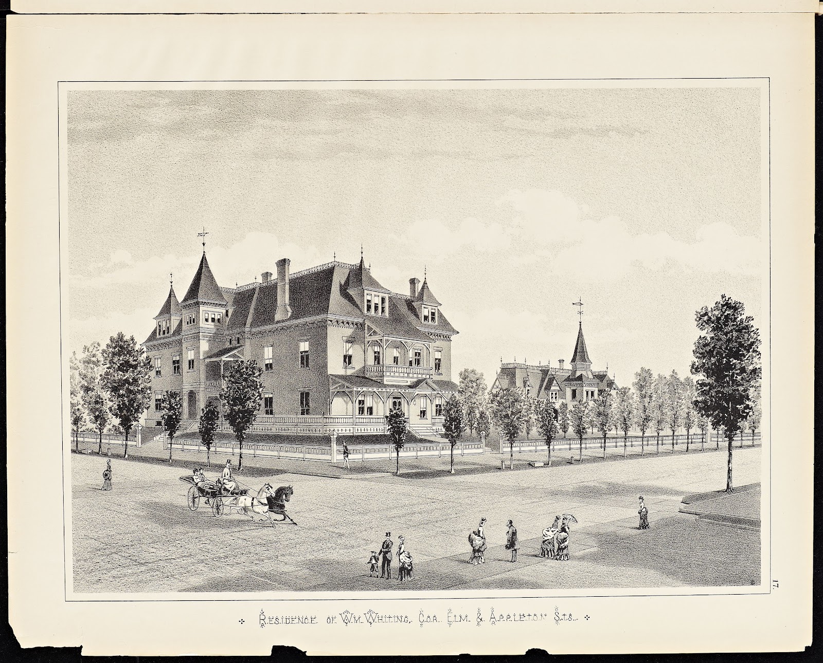
Some of the atlases also include drawings of prominent homes, schools and other important buildings. An example of this is the residence of Wm. Whiting found in the 1884 Atlas of Holyoke City, Massachusetts published by Geo. H. Walker & Co.


The Massachusetts real estate atlas digitization project, to be completed by the summer of 2013, has been developed with federal funds provided by the Institute of Museum and Library Services and administered by the Massachusetts Board of Library Commissioners.


Monday, February 27, 2012

Digitization project to make Massachusetts atlases available on the web

As part of a grant-funded project, the State Library has started to digitize the Massachusetts Real Estate Atlases in its collection. The library has approximately 200 atlases, which include about 6500 maps in 12 counties and more than 80 municipalities throughout Massachusetts. These atlases provide information about property boundaries, plot size, ownership, building shapes and materials and are heavily used by genealogists, architectural consultants, people researching the history of their homes and others.

The image on the left is from George Washington Bromley’s Atlas of the City of Boston, volume 1, published in 1883. It shows the State House before the back half of the building was added in the 1890’s and before the east and west wings were added in the early 20th century. It also shows the properties that were taken to make room for these additions.

The image on the right is from the Atlas of Hampden County, Massachusetts, published by F. W. Beers in 1870. It shows the center of South Wilbraham.

The first group of 45 atlases currently being digitized include a statewide Massachusetts atlas, atlases from Middlesex, Franklin and Worcester counties and municipal atlases that cover 45 cities and towns throughout the state from Pittsfield to New Bedford. These materials should be digitized and in our electronic repository by late spring. The entire project is expected to be completed by summer, 2013.

The Massachusetts real estate atlas digitization project has been developed with federal funds provided by the Institute of Museum and Library Services and administered by the Massachusetts Board of Library Commissioners.