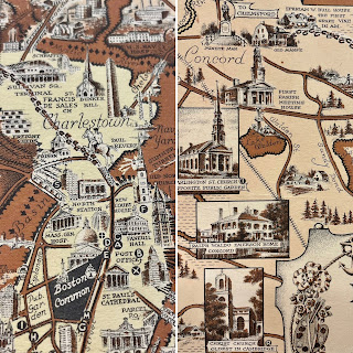
Happy June! Now that the summer months are upon us, Boston will become even busier with visitors. Whether you are a local playing tourist for the day, or an out-of-towner experiencing the city for the first time, our displayed item will provide some inspiration for things to do and places to see. Visit us throughout the month to see the Ernest Dudley Chase map Boston and Vicinity: A Pictorial Map on display in our main reading room.
Ernest Dudley Chase was born in Lowell, Massachusetts in 1878 but lived most of his life in Winchester (which case be found at the top center of this map). He was an illustrator who was known for his greeting cards and his pictorial maps. Pictorial maps will not help you out very much if you are trying to figure out how to get from one location to another, but they will entertain you with their whimsical illustrations and depictions of an area. While many of Chase’s maps focus on New England, he did not limit himself to the region. The State Library holds several of Chase’s maps in our collection, and while not all of them have been digitized yet, you can explore a full list here. Many of Chase’s maps focus on New England, but you can see from our holdings that he did not limit himself to the region. Maps in our collection include world maps, other locations within the United States, European countries, and themed maps - like “love” and “peace.” You can also explore more of Chase’s life and work in our 2009 online exhibit Ernest Dudley Chase: A Worldview in Maps.
Our displayed map of the Boston metro area is so detailed that each time you look at it, you are bound to find something new. It is peppered with illustrations of buildings, landmarks, train routes and various modes of transportation, and bodies of water. The map extends north to Melrose, Lexington, and Concord, west to Wayland and Natick, and south to Needham, Mattapan, and Wollaston. Boston Harbor and Thompson’s Island, South Boston, East Boston, and Revere are shown to the east. Countless numbers of schools, churches, municipal buildings, and libraries are among the illustrated buildings, along with recreational related sites like golf courses, yacht clubs, and beaches and amusement parks. For those who want a little bit of history included in their maps, Chase even included the route of Paul Revere’s midnight ride! He’s depicted on horseback leaving Old North Church, and then you can follow the horseshoe tracks all the way to Concord (the map does not address that William Dawes and Samuel Prescott were also part of this ride, and that Revere was detained and didn’t make it all the way to Concord!).Whether you are visiting the Boston metropolitan area for a week-long vacation or just looking for inspiration for a daytrip, you can find numerous destination suggestions in this map. And be sure to stop by one of the featured locations, the State House, to visit the State Library and see this map on display through June 27.
Elizabeth Roscio
Preservation Librarian

