Showing posts with label Massachusetts. Show all posts

Monday, July 17, 2023

Summer at the State Library: Cape Coddities, Trail Maps, Novels, and More!

Summer is officially here! And the State Library has something for everyone to read and enjoy. Stop by the reading room (room 341 of the State House) to check out our latest display on the Cape and Islands. We have selected some unique titles from the collection which highlight Cape Cod, Nantucket, and Martha’s Vineyard - popular vacation spots for many New Englanders! 

Cape Cod Old Salt, 1935 - Published by the Cape Cod Chamber of Commerce and the Hyannis Board of Trade in support of the Cape Cod Canal Bridges, this pamphlet offers a collection of photographs of “old Cape Cod.” Of particular interest, there is a photo of the Legislature’s Committee on Railroads visiting Hyannis in 1896 (p. 7). Throughout the pamphlet are vintage advertisements for everything from theaters, to inns, ice cream shops, to general stores all located down the Cape.

Cape Cod IQ - Test your Cape Cod knowledge with this 1951 pamphlet which cost only 35 cents! This fun little pamphlet includes over 250 questions and answers as well as some Cape Cod lore. Here’s two questions from the pamphlet: In what town does the eastern entrance to the Cape Cod Canal lie? What town was the site of the Marconi wireless station?

Answers at the end of this blog post!

Nantucket, 1925 - We love this colorful pamphlet by Walter Prichard Eaton with illustrations by John Held Jr. The pamphlet includes a history of the island written by Prichard, with points of interest, details of the island’s architecture, beaches, popular sports, with fun illustrations and photos throughout.  

Cape Coddities - This 1920 book by Dennis and Marion Chatham (a fitting last name) is a collection of essays that “should not be taken as a serious attempt to describe the Cape..” Included are quirky essays on scallop farming, the Cape’s freshwater ponds, cottages and more. 

We hope these items inspire your next beach trip or bring about a sense of nostalgia for past summer trips.

Speaking of beach trips - looking for a good book to bring to the beach? State Employees, come check-out some of our latest titles or use your State Library card to download Libby and read ebooks no matter where you go this summer. Non-state employees, if you’re looking for a spot to cool down, the library is open, Monday through Friday, 9-5. 

In addition, reference services are available for all your research needs whether you are an intern or taking a summer course, we are here to help you navigate legislative materials. Contact us via email at reference.department@mass.gov


Answers: Sandwich and Wellfleet


April Pascucci 
Legislative Librarian


Monday, July 3, 2023

On Display in the State Library

Massachusetts is home to a number of great libraries and has been for many years! But do you know just how many libraries were functioning in Massachusetts in the late 1800s? Visit us throughout this month to find out! We’re displaying Free Public Libraries of Massachusetts, a map designed and hand-drawn by George Hartnell Bartlett in 1893.

While we were closed to the public in 2021, we shared a 1904 version of this map in our “virtual display case.” You can read more about that version and about Bartlett himself here. The version that we’re displaying this month differs a bit in design. Instead of drawings of each library, this map is much more number focused. In this version, each city or town is identified along with a number signifying its population. If the town includes a library, then a little book is drawn, and within that book is a number that shows how many volumes are included in its library. For example, Worcester has a population size of 84,656 and a volume size of 89,268 - enough for each person in the city to check out a book at the same time, and then still have almost 5,000 left on the shelves! The map also gives some state-wide figures and shows that in 1893 there were 352 cities and towns in Massachusetts and 300 of them had free public libraries. In 1892, the number of volumes circulated for home use throughout the Commonwealth was 5,040,629 – that’s pretty impressive considering that the population of Massachusetts at the time of the 1890 census was 2,228,943!

We typically try to highlight a collection item that has some sort of seasonal connection, and at first glance this might not seem like a likely contender for July, a time when in the past we’ve shared more blatantly patriotic items like our newspaper copy of the Declaration of Independence, our broadside version of the Declaration of Independence, a 1849 program of 4th of July events and an 1890 photograph of the State House adorned in bunting. But this map is, in fact, a timely collection item because it speaks to the role that libraries play in supporting our democratic society. Massachusetts is home to the first and longest continuously running public lending library. The town of Franklin was incorporated in 1790 and was named after Benjamin Franklin. When it was suggested that Franklin donate a bell for the meeting house tower, he instead donated a small collection of books. This collection went on to become the foundation of the first circulating library in the country, accessible to all citizens in the town, and is still currently housed at the Franklin Public Library. Of the donation over books instead of a bell, Franklin was said to have stated that “sense” was preferable to “sound.” And as Thomas Jefferson, author of the Declaration of Independence, is quoted as saying, “an educated citizenry is a vital requisite for our survival as a free people." Both quotes support the statement that libraries are a cornerstone of our democracy. Libraries give citizens the opportunity to establish and engage in an informed discourse, which is at the foundation of a free society. Circulating collections, database access, public programming, and research assistance are just some of the ways that librarians strive to provide all citizens, regardless of race, religious affiliation, age, gender, with safe access to resources and services that promote education, well-being, and engagement.

From the first circulating library in 1790, to the publication of this map in 1893, to today, libraries have been hubs of resources for those seeking knowledge. Check out the American Library Association’s Bill of Rights to see the policies that libraries abide by to ensure that they continue to be forums for information for all. And stop by the library throughout the month to see the map of Commonwealth libraries on display! If you can’t visit us in person, click on the image above or explore a high-resolution copy available through the Norman B. Leventhal Map Center at the Boston Public Library.


Elizabeth Roscio
Preservation Librarian


Monday, May 29, 2023

On Display in the State Library

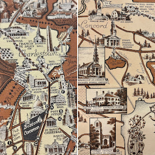
Happy June! Now that the summer months are upon us, Boston will become even busier with visitors. Whether you are a local playing tourist for the day, or an out-of-towner experiencing the city for the first time, our displayed item will provide some inspiration for things to do and places to see. Visit us throughout the month to see the Ernest Dudley Chase map Boston and Vicinity: A Pictorial Map on display in our main reading room.  

Ernest Dudley Chase was born in Lowell, Massachusetts in 1878 but lived most of his life in Winchester (which case be found at the top center of this map). He was an illustrator who was known for his greeting cards and his pictorial maps. Pictorial maps will not help you out very much if you are trying to figure out how to get from one location to another, but they will entertain you with their whimsical illustrations and depictions of an area. While many of Chase’s maps focus on New England, he did not limit himself to the region. The State Library holds several of Chase’s maps in our collection, and while not all of them have been digitized yet, you can explore a full list here. Many of Chase’s maps focus on New England, but you can see from our holdings that he did not limit himself to the region. Maps in our collection include world maps, other locations within the United States, European countries, and themed maps - like “love” and “peace.” You can also explore more of Chase’s life and work in our 2009 online exhibit Ernest Dudley Chase: A Worldview in Maps.

Our displayed map of the Boston metro area is so detailed that each time you look at it, you are bound to find something new. It is peppered with illustrations of buildings, landmarks, train routes and various modes of transportation, and bodies of water. The map extends north to Melrose, Lexington, and Concord, west to Wayland and Natick, and south to Needham, Mattapan, and Wollaston. Boston Harbor and Thompson’s Island, South Boston, East Boston, and Revere are shown to the east. Countless numbers of schools, churches, municipal buildings, and libraries are among the illustrated buildings,  along with recreational related sites like golf courses, yacht clubs, and beaches and amusement parks. For those who want a little bit of history included in their maps, Chase even included the route of Paul Revere’s midnight ride! He’s depicted on horseback leaving Old North Church, and then you can follow the horseshoe tracks all the way to Concord (the map does not address that William Dawes and Samuel Prescott were also part of this ride, and that Revere was detained and didn’t make it all the way to Concord!). 

Whether you are visiting the Boston metropolitan area for a week-long vacation or just looking for inspiration for a daytrip, you can find numerous destination suggestions in this map. And be sure to stop by one of the featured locations, the State House, to visit the State Library and see this map on display through June 27. 


Elizabeth Roscio
Preservation Librarian

Monday, March 21, 2022

Hopping into Spring!

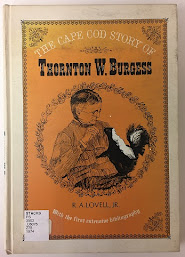
Happy Spring! Did you know that Massachusetts was home to beloved naturalist and author Thornton Burgess. Born in Sandwich in 1874, Burgess was responsible for writing over 170 children’s books inspired by the woodland creatures native to the Cape Cod area. His most famous character being Peter Cottontail, from his 1914 book, The Adventures of Peter Cottontail. This is not to be confused with Beatrix Potter’s rendition of Peter Rabbit.

Peter Cottontail as illustrated by Harrison Cady.
Image courtesy of Thornton Burgess Society.

Throughout his 50 year career, Burgess contributed to his Old Mother West Wind series with characters known as Jerry Muskrat, Bobby Raccoon, Spotty the Turtle, among others. However, it was illustrator, Harrison Cady, who brought these characters to life. Another Massachusetts native, Cady was born in Gardner in 1877. Burgess and Cady would go on to have a lasting business partnership and friendship.

Today, the Thornton Burgess Society along with the Cape Cod Museum of Natural History, work to preserve and carry-on the mission of Burgess to instill an appreciation for nature among our communities. For more information, see www.thorntonburgess.org.

For continued reading held in the State Library’s collection:


April Pascucci
Reference Staff


Monday, March 7, 2022

Atlas Collection at the State Library

Did you know that the State Library has a large collection of real estate atlases documenting the development of cities and towns in Massachusetts? Most of the Library’s atlases date from the 19th and 20th centuries and provide information about property boundaries, plot sizes, ownership, and building shapes and materials. These atlases are an invaluable resource for genealogists, environmental consultants, architectural historians, and the general public who are researching the history of a particular property in Massachusetts.

1911 Atlas of Salem

The Library’s collection of real estate atlases includes approximately 200 atlases, 167 of which have been digitized and made available in the Library’s online repository, DSpace, as well as our Flickr site. Take a look at them and see if you can find your own town in our online collection. You can also search the Library’s online catalog for atlases and other resources about your town using our advanced searchour advanced search.  If you have any questions regarding the State Library’s collection of real estate atlases, please contact our Special Collections Department at special.collections@mass.gov.


Silvia Mejia
Special Collections


Monday, February 28, 2022

Currently on Display in the State Library

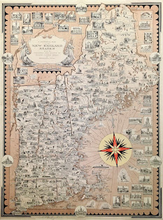
This month, we’re excited to remind you that you can now visit the library and view our featured collection item in person! Currently on display in the State Library’s reading room is A Pictorial Map of the New England States, U.S.A. by renowned cartographer Ernest Dudley Chase. Dating to 1939, it is an illustrated map of the six states that comprise New England: Connecticut, Rhode Island, Massachusetts, New Hampshire, Maine, and Vermont.

Read about this map in our previous blog post, and then visit us to check out all its intricate details in person. The State Library is open to the public Monday through Friday from 9:00 to 5:00. The public can access the State House through the Ashburton entrance and be sure to check the requirements for entry before you visit. 

For those of you who can’t visit us, we’d also like to share a few of the other Ernest Dudley Chase maps found in our Special Collections.

Above left is France as drawn by Ernest Dudley Chase in 1935. This map has a fleur de lis border and shows an illustration for each French town. Paris has an illustration of the Eiffel Tower, the Arc de Triomphe and Notre Dame. There are also illustrations of landmarks flanking the map. And above right is The United States as viewed by California (very unofficial). A California-centric map “distorted and drawn” by Ernest Dudley Chase in 1940. It shows planes, trains, cars, and buses speeding across the rest of the country on the way to California, and we appreciate the annotation for New England that it is “kissed by the sun part of the time. After all, many Californians, or their forbears, came from this section.”

And lastly, published by the Massachusetts Department of Commerce and Development in 1956 is Historic Massachusetts, a travel map to help you feel at home in the Bay State. The map identifies Massachusetts as “a world of fun and relaxation” and it includes illustrations of the state’s landmarks and activities, along with an inset of Greater Boston. A useful tool for any tourist!


We’ll be changing the library’s display case at the beginning of each month, so stay tuned to see what other items will be exhibited in the months to come. And as always, we’ll continue to share the featured item through our blog and social media for those who can only visit us remotely.


Elizabeth Roscio
Preservation Librarian

Wednesday, February 2, 2022

Happy Groundhog Day!

February 2 is well-known in the United States, and especially in our Commonwealth of Massachusetts, as Groundhog Day. We are proud to honor today Ms. G, the Massachusetts State Groundhog. Ms. G is a female groundhog living at Mass Audubon Drumlin Farm Wildlife Sanctuary in Lincoln, Massachusetts. She has been forecasting the weather on Groundhog Day since 2008.  

The story of Ms. G’s official designation as the Massachusetts State Groundhog is well-documented in several places, including her own website and in a beautifully-written book by meteorologist Mish Michaels called Ms. G's Shadowy Road to Fame. The illustrations by Kathleen Jameson bring the story to life. After hard work by students at Hunnewell Elementary School in Wellesley, and with help from State Representative Alice Peisch and other dedicated fans of Ms. G, Governor Deval Patrick signed the bill into law on July 31st, 2014.

In our 2017 exhibition on state symbols of Massachusetts, we used a stuffed animal purchased from Mass Audubon Drumlin Farm to illustrate Ms. G’s status as the State Groundhog. A photograph of the real Ms. G is here. Please join us in wishing her a long and healthy life!


Beth Carroll-Horrocks
Special Collections

Monday, March 22, 2021

Old Photographs of Boston

During a major cataloging project at the State Library, the staff rediscovered many of our beautiful collections, including maps, photographs, and manuscripts. These collections are now fully cataloged and can be found in our online catalog.

One of my favorites is the “Photographs of Old Boston” collection, which we were able to digitize and can be found in the Library’s digital repository, DSpace or through the Library’s Flickr page.

Public Garden, 1857
This album was acquired by the State Library from G.H. Marsh in 1907 and consists of 49 black and white photographs that provide views of Boston during the 19th century. It shows historic buildings, storefronts, cathedrals, and well-known Boston sites like the Garden and the Old State House, as well as places that no longer exist like the John Hancock house. What is interesting about these photographs is how certain places have changed but also how they have remained the same.
John Hancock House,
1860

 You can access the full collection from either   DSpace or the Library’s Flickr page.


 Silvia Mejia
 Special Collections Librarian
 State Library of Massachusetts


Monday, April 22, 2019

When Does a Bill Go into Effect in MA?

According to the Legislative Research and Drafting Manual, in Massachusetts a bill has the “force of law” when “(1) the Governor signs it, (2) when the Governor lets a bill become law by taking no action on the bill for 10 days after it is ‘laid before the Governor,’ (3) when both houses of the Legislature, each by a two-thirds roll call vote, pass the bill over the Governor’s veto, or (4) if an initiative petition is successful.”

When a bill becomes a law, it doesn’t usually go into effect right away.  It’s important to first look at the language of the bill, which will help determine what kind of law it is and when it will take effect in Massachusetts.  Here are some rules to keep in mind:

90 Days:
General legislation of a permanent nature, without an emergency preamble, becomes effective 90 days after being signed by the governor, which includes weekends and holidays.  The delay gives voters time to start the referendum petition process if voters want to repeal the law.

30 Days:
Acts that are not subject to a referendum typically take effect after 30 days, unless otherwise stated in the text of the law.  Special acts often fall under this category.

Laws that are not subject to a referendum include laws about: religious matters; the appointment, tenure, and removal of judges; the powers of the courts; if the law is restricted to a specific city or town; or appropriation acts.

Immediately:
Some acts are declared “emergency laws” and have emergency preambles that state that the passage of the law is “necessary for the immediate preservation of the public convenience [or health, or safety];” both the House and Senate must first approve emergency preambles.  Emergency laws go into effect immediately, even if they are subject to a referendum process.

Similarly, the governor can also file an emergency letter with the secretary of the commonwealth’s office to have a law become effective immediately, even if it is subject to a referendum.

Resolves take effect immediately unless the text of the resolve states otherwise.

Other:
Some acts have specific provisions regarding effective dates, which can usually be found in the last section of the act.  It’s also important to note that an act can also be made up of sections that have different effective dates.


Sources:
Legislative Research and Drafting Manual (downloads as pdf)

Handbook of Legal Research in Massachusetts by Mary Ann Neary et al.


Kaitlin Connolly
Reference Department


Monday, May 21, 2018

State Government Open Data

From March 12th to April 30th I completed the Civic Data Ambassadors program, which was offered by the City of Boston in collaboration with the Engagement Lab at Emerson College.  The program was advertised to Boston librarians who were curious about civic data and were interested in becoming Civic Data Ambassadors.  As student ambassadors, we learned about what civic data is, how it can be used to answer questions, how it impacts the Boston community, methods on searching and filtering open data, tools that can be used to create visualizations that can help with analysis, and how to identify when someone else can make use of such data.  “Open data,” as defined by the Open Data Handbook, is data that “can be freely used, re-used and redistributed by anyone;” “use” could mean simply viewing the information for general interest or research purposes, or it could mean using it to create a helpful tool (i.e. weather app, traffic app, etc.).  As part of the course we completed projects using primarily the open data published in Analyze Boston; however, I came out of the program wanting to learn more about open data that is published by the Massachusetts state government.  It’s important to keep in mind that data is just as important and useful for research as published reports are—maybe even more so!  Below are examples of open data portals available online that are maintained by state and quasi-state agencies on a regular basis; they also allow data to be downloaded or exported into user-friendly formats (i.e. CSV and Excel files).

Dataset titled “Lead and Copper Drinking Water Results in Schools/Childcare,”
published via the Office of Energy and Environmental Affairs Data Portal.


General
MassData: the Open Data Initiative for the Commonwealth of Massachusetts

Education
Massachusetts Department of Higher Education Data Center
MA Department of Elementary and Secondary Education (DESE) School & District Statewide Reports

Transportation
Massachusetts Department of Transportation (MassDOT) Open Data Portal
Massachusetts Bay Transportation Authority (MBTA) Data Dashboard

Financial/Economic
Office of the Comptroller’s CTHRU:  Financial Records Transparency Platform
Massachusetts Water Resources Authority Open Checkbook
Division of Banks Foreclosure Petition Website
Massachusetts Office of Campaign and Political Finance Contributions and Expenditures Data
Department of Unemployment Assistance - Labor Market Information (LMI)

Energy and Environment
Office of Energy and Environmental Affairs (EEA) Data Portal
Mass Save Data

Health
Center for Health Information and Analysis (CHIA) Databooks
Massachusetts Environmental Public Health Tracking

Municipal
Division of Local Services (DLS) Municipal Databank
Metropolitan Area Planning Council (MAPC) Open Data

If you are interested in Geographic Information System (GIS) mapping, check out our earlier blog about shapefiles, data layers, and mapping tools published by the state: http://mastatelibrary.blogspot.com/2016/12/massachusetts-interactive-mapping.html 


Kaitlin Connolly
Reference Department


Monday, February 26, 2018

A Congressional Duel and Massachusetts’ Reaction

This past Saturday marked the 180th anniversary of a fatal duel between two United States congressmen.  On February 24th, 1838, in Prince George’s County, Maryland, right outside the border of the District of Columbia, a duel between Representative Jonathan Cilley of Maine and Representative William J. Graves of Kentucky was held, which resulted in the death of Cilley after three rounds with rifles.  The trouble began when Cilley accused James Watson Webb, editor of the New York Courier and Enquirer, of taking bribes.  Webb responded to these accusations through a letter and asked Graves to deliver it to his detractor, who declined to accept it.  Further discussion between Cilley and Graves about the refusal worsened the situation and, although they had no known grievance against one another prior to this, Graves felt that his character was also under attack and challenged Cilley to a duel.  Three days after Cilley’s death a funeral, attended by President Martin Van Buren, was held in the U.S. House Chamber.

The Massachusetts General Court was horrified by the event and, in official statements, called the practice “savage, cowardly, and abominable” before amending the language to “immoral, unchristian, and unlawful.”  Massachusetts laws prohibiting duels and levying punishments on participants go back as far as the early 18th century, as evidenced in the following acts:


A joint select committee was quickly formed in the General Court to review the matter and to determine what action, if any, should be taken.  The committee’s scathing report found that, despite most states having laws in place against dueling, one major problem was an overall “reluctance on the part of the public, to prosecute and convict … offender[s]” due to the sentiment of bravery and honor associated with it.  The report also pushed federal legislators to use their influence and “all reasonable exertions” to “procure the passage of a law by Congress” that would suppress the custom once and for all—with many states submitting similar petitions.  In February of 1839, after a lengthy debate in the U.S. Congress, a law was passed (Chap. 30) that criminalized the challenging or acceptance of duels in the District of Columbia; this law strengthened earlier 18th century laws in DC that merely banned the act itself.  As public opinion changed over time, dueling in the United States saw a decline during the Civil War era and eventually came to an end in the 1880s.


Other congressional duels:
Further reading:


Kaitlin Connolly
Reference Department


Monday, December 12, 2016

Massachusetts Interactive Mapping & Geographical Data Tools

Geographical mapping technology has gone a long way in just a short 30 years.  Many interactive tools have been or are being developed and data can now be updated quickly—sometimes even through live raw data feeds.  Data can also be manipulated and shared openly with users through web viewers and downloadable formats (shapefiles, Keyhole Markup Language (KML), etc.) so that it can be integrated into other projects.

Massachusetts state agencies, such as the Office of Geographic Information (MassGIS) and the Massachusetts Department of Transportation (MassDOT), have developed interactive mapping tools that are available for use by the public.  There’s a little bit of a learning curve when first attempting to use them, however just exploring their different functionalities is a lot of fun and often produces interesting results.  In addition to the tools linked below, use the Mass.gov search bar to find mapping tools other agencies provide (keywords such as “geographic information” and “GIS tool” are great starting points.)

Massachusetts' bedrock lithology as detailed through data layer
group B, using MassGIS' Oliver Online Map Maker.

Office of Geographic Information (MassGIS) tools:
  • Oliver: The MassGIS Online Map Maker:  Allows users to “interactively display and query nearly all of MassGIS’ data” and download up-to-date shapefiles from the database.
  • ArcGIS Online Web Mapping Platform:  “A statewide database of geospatial information.”  Interactive tools include Google Ortho Imagery and Index, MassUtilities, Surficial Geology, and property maps.
  • MassGIS Datalayers:  Datalayer descriptions with metadata and links to free downloadable data.

Massachusetts Department of Transportation tools:


Kaitlin Connolly
Reference Department


Monday, November 14, 2016

Researching Early (Legal) Name Changes in Massachusetts

A page from the 1905 Acts and Resolves 
listing the name changes that occurred
in Essex and Franklin counties during
the year 1904. 

Everyone has the right to legally go by the name of their choice, as long as it is not done for illegal or fraudulent purposes.  Today, the procedure for changing your name in Massachusetts includes filling out a form (petition), and filing the petition with your county’s Probate and Family Court (or the Juvenile Court for minors).  For more information, visit: http://www.mass.gov/courts/selfhelp/name-changes/

Prior to 1852, if an individual wanted to change their name, he or she had to submit a petition to the General Court; once approved, the petitions were subsequently published as special acts of the legislature.  Such special acts can be helpful to researchers and genealogists who are trying to track down the original name of a person, the name they legally adopted, when the person initiated the change, and in what city they were residing at the time.  Not too long ago it was discovered that the Gloucester painter formerly known incorrectly as “Fitz Hugh Lane” had actually adopted and used the name “Fitz Henry Lane” in his lifetime, as recorded in Chapter 124 of the Acts of 1832.  Such special acts containing name changes can be found, either by browsing or using a keyword search, in the library’s acts database-- which covers the years 1692 through 2010: http://archives.lib.state.ma.us/handle/123456789/2
An 1835 pencil drawing of Fitz Henry Lane
by Robert Cooke.  Three years earlier Lane was
known by his birth name Nathaniel Rogers
Lane. By Robert Cooke (American
Antiquarian Society, Worcester, Mass.)
 [Public domain], via Wikimedia Commons.

Another great resource collated and published by the Secretary of the Commonwealth back in 1893 is the book List of Persons Whose Names Have Been Changed in Massachusetts: 1780-1892.  Unlike the acts database, it also includes data from the annual name change returns submitted to the Secretary by the county probate courts.  An online version of this book is also viewable and downloadable through HathiTrust.org.

If you are looking for information after 1892, annual lists of name changes can also be found in the Acts and Resolves volumes from 1853 through 1913; these volumes have been digitized and can be accessed via the library’s website. 

Original petitions submitted to the legislature that were and were not approved can be found at the Massachusetts State Archives.


Kaitlin Connolly
Reference Department


Monday, October 17, 2016

Researching the History of Your Property in Massachusetts

The doorway of "The Stearns House,"
which was built in 1776. Image from
Historic Doorways of Old Salem (1926)
by Mary Harrod Northend.
Massachusetts has some of the oldest and most historically significant buildings in the United States—in fact, you may own or live in one.  Researching the history of your home can be fun and informative, in understanding both past ownership as well as learning about the original footprint of the structure and surrounding property; the latter is especially important if you’re interested in preservation and restoration.  Below is a list of essential and supplementary resources that will help you gather documentation that traces the history of your home.

Online resources:
Massachusetts Land Records:  A database provided by the Registry of Deeds that maintains both historical and current land records for properties across the Commonwealth.

State and Federal Censuses:  The census population schedules record who and when people were living on certain properties.  They also include additional information, such as age, place of birth, occupation, and property value.  Most, if not all, early censuses are now available online.

Massachusetts Cultural Resource Information System (MACRIS):  A database of historical properties provided by the Massachusetts Historical Commission.  Since this database should not be considered exhaustive, it may be good to contact the MHC to see if they have additional properties on file.

Partial image of a plate taken from the 1906 atlas
of the city of Lowell.
Real Estate Atlases: The State Library has digitized a large portion of its collection of real estate atlases that cover many of the cities and towns in the state.  These atlases, mostly from the late 19th and early 20th centuries, document the names of property owners, the foot print of structures, as well as what the structures were made of.  The library also has atlases that were not able to be digitized; please check our online catalog for additional materials.

Historic New England Collection Database:  Users can browse or search for architectural drawings and interior photography of historic homes in this online database of Historic New England’s collections.

Resources not available online:
Massachusetts Directories:  City and town directories, which were usually published on a yearly basis, list residents alphabetically by last name (much like a phone book), along with their street address and occupation; the volumes also include the names and addresses of businesses.  Some directories have house guides with listings sorted by address and not by the residents’ last names.  Many Boston directories have been digitized and are available online.  Make sure to check with your local library to see if they have historical directories for your area.

City and town annual reports:  Early municipal fire department reports often list the location at which a fire-related event occurred, sometimes including the owner’s name(s), and, if known, the physical and monetary extent of the damage.  If you suspect that your house once experienced a fire, these reports may help you track down what happened and when.  Other departmental reports may also provide data about neighborhoods and development.  The State Library has a large collection of such reports, and your local library may also have their own collection.

Tax Valuations:  Tax valuations help identify individuals’ names and property holdings.  The library has valuations for various cities and towns up to 1811 on microfilm.

Probate Records:  These court records are especially helpful if a piece of property transferred ownership through an inheritance.

Private publications:  There are many books that compile the histories of cities and towns, as well as local architecture.  You can check our online catalog for such materials, and also make sure to check your local library.

Historical Newspapers:  Do you suspect something happened on your property on a specific date or within a certain time frame?  Maybe the event was covered in a local newspaper.  If you’re having trouble locating a particular title or issue, the Boston Public Library has one of the largest historical newspaper collections in the area. The State Library also has a collection of newspapers; peruse our online list to see which titles we have available.

Local government and cultural institutions:  Municipal departments oversee many functions that record changes to properties, such as building permits (the City of Boston even provides an online permit database) and tax assessments.  Most cities and towns also have a public library, an archives, and/or an historical commission.  Many of the resources listed in this blog, as well as records unique to the institution’s collections (photographs, maps, building plans, newspapers, etc.), can be accessed without having to travel too far from home.  In the case of local historical commissions, many homes already have compiled research on file.

Kaitlin Connolly
Reference Department


Monday, March 14, 2016

Chickadees in a Cracker Jack box


The State legislature designated the chickadee as the “bird or bird emblem of the commonwealth” in 1941. A few years ago, in preparation for an upcoming exhibition on birds in Massachusetts*, the State Library’s Special Collections Department started collecting objects and images relating to our state bird. A surprising number of friends and family members had chickadee memorabilia to contribute, and the collection has continued to grow through donations.

Acts and Resolves passed by the General Court. 1941 Chapter 0121.

In early 2015 a small gift joined the collection: a prize from a 1940’s Cracker Jack box. The prize was a miniature booklet (2 ¾”h x 2 1/8”w) titled Chickadee, by John H. Eggers, with a copyright date of 1941. Not necessarily of great research value, but this item will be a charming addition the next time we do an exhibition on printing techniques, or birds, or state emblems.


*Amazing Birds: The Wild Side of Massachusetts, June-August 2012; see images on the State Library’s Flickr page.

Special Collections Department

Tuesday, January 19, 2016

Celebrating Martin Luther King, Jr. and his Massachusetts Connection

Martin Luther King
image from Wikimedia Commons
This week the nation pauses to honor the extraordinary life and legacy of Dr. Martin Luther King, Jr. on what would have been his 87th birthday. The holiday honoring King was signed into law by President Ronald Reagan on Nov. 2, 1983 (Public Law 98-144) and was first observed at the federal level on Jan. 20, 1986. What is lesser known is that Massachusetts was one of the first states (after Illinois and at the same time as Connecticut) to establish King’s birthday as a legal holiday over a decade earlier than the federal government by passing “An Act Establishing Martin Luther King’s Birthday as a Legal Holiday” on July 8, 1974  (Chap. 493, Acts of 1974). The holiday reminds us to focus on the legacy of Dr. King’s ideals—civil rights and human equality, the use of nonviolence to promote change, and encouraging people to answer to the call to public service.


Senator Edward Brooke
image from Wikimedia Commons
Massachusetts Republican U.S. Senator Edward Brooke (along with U.S. Representative colleague John Conyers, D-Michigan) led the federal effort to make King’s birthday a national holiday by introducing the first bill in Congress in 1979 (the 50th anniversary of King’s birth), an effort that would fall short by only 5 votes of the two-thirds needed for passage. A House bill establishing the holiday would ultimately prove successful 5 years later after Brooke had left office but his tireless commitment to the federal King holiday bill laid the considerable groundwork for its passage. Speaker of the House Tip O’Neill (D-Massachusetts) got a standing ovation after his closing remarks recommending passage of the 1983 House bill and Sen. Edward M. Kennedy (D-Massachusetts) was the sponsor of the same bill in the Senate and gave a passionate defense of Dr. King during a contentious Senate debate (detailed in a New York Times article from Oct. 1983).

Dr. King was warmly welcomed to the Massachusetts State House on April 22, 1965 to address the Massachusetts General Court—this was nearly 2 years after giving his most famous “I Have a Dream Speech” at the Lincoln Memorial in the summer of 1963. The inspirational words in his speech to the Massachusetts General Court can be found in the text of House Bill no. 4155 of 1965 and can be accessed HERE in the State Library’s DSpace digital repository. Reading his speech again, one finds that his words are just as powerful and relevant today in 2016 as they were in 1965.

Judy Carlstrom
Technical Services 

Monday, August 17, 2015

Video Resources That Can Help You With Your Legislative Research

Many researchers who visit the State Library for legislative research purposes also inquire about
videos of executive branch coverage or legislative proceedings.  Here are some recommendations that we at the library have found to be particularly helpful over the years.

State Library’s House and Senate Floor Session Video Collection
Allowing my bias to take the reins, I will first mention the library’s videotape collection of House and Senate floor sessions (i.e. debates).   Housed in our Special Collections Dept. (Room 55 of the State House), the collection goes as far back as November of 1987 when the library began receiving copies of these videos.  Important to note is that from 1987 to 1993 the videos are that of the House only.  In addition to floor sessions, the collection also contains a handful of committee hearings.  Knowing if it’s House or Senate you want to see, and a specific date, is most helpful for our librarians when requesting video availability.  Our videos must be viewed on site, and copies cannot be produced by the library.  If you have any questions about our video collection, you can contact our Special Collections Department at 617-727-2595, or by email at special.collections@state.ma.us.

Massachusetts House and Senate Broadcasts: http://masslegislature.tv
This website provides “access to live gavel-to-gavel proceedings” of the legislature.  There is also an archive of videos, going back as far as January of 2007.  The types of videos you will find here include committee hearings, formal House sessions, Senate sessions, Joint sessions, and other events (ex. inaugural addresses, roundtables, etc.)  You can search by exact date or date range, by keyword, or you can browse the list by clicking “List all archived events.”

The Massachusetts Legislature’s Website:  https://malegislature.gov/Events/Search 
The legislature’s website allows users to search its “Events Archives,” which includes House, Senate, and joint sessions, committee hearings, and other special events.  The archive goes back as far as April of 2007, but it’s important to remember that not every event listed in the archive has a video.  If a particular event had a video available, a green video camera icon will appear to the right of the event name.  Users can search for an event by exact date or date range, or by keyword.

State House News Service: http://www.statehousenews.com/
SHNS is an independent, subscription-based wire service that covers the activities of the state’s government year-round.  Their multimedia content includes videos of interviews and events, as well as audio recordings, organized by date, of House and Senate sessions.  Patrons of the State Library can access SHNS onsite in the library.

Boston TV News Digital Library: http://bostonlocaltv.org/
This website is an archive of news content produced by a number of Boston-area TV news programs, and covers the years 1960 through 2000.  Users can search the collections through a general keyword search that, when submitted and results are yielded, allows for additional filters (collection, places, date).  Videos (including interviews) of governors, legislators, and committee hearings, and various other institutions and events can be found within this digital library.

C-Span Video Library: http://www.c-span.org/
C-Span focuses on televising the proceedings of the federal government, but other public affairs programming is available in their online video archive.  Videos can be searched by typing in a keyword in the search bar near the top of the home page, and also by choosing “videos” from the drop down menu to the left of the bar.  For example, searching “Charlie Baker” (with quotes) yields 10 results, including press conferences and gubernatorial campaign coverage.  Once results are yielded, users can narrow down their topic with a variety of additional filters.

YouTube:  https://www.youtube.com/
Almost everyone is familiar with YouTube, but it’s often overlooked as a resource for legislative proceedings or executive branch coverage.  While the videos are not as organized or curated in the same way as the above mentioned websites, the benefit is that you can cast a wide net and discover videos that you may not find anywhere else.  For example, if you search for “Massachusetts legislature” hearing, various videos of committee hearings and testimony are among the list of results.

Kaitlin Connolly
Reference Department

Monday, March 2, 2015

William Bradford’s manuscript volume “Of Plimoth plantation” now available online

Bradford manuscript special display case (bottom right)
in main Library, ca. 1908.

In 2014 the State Library completed a major project to conserve and digitize one of the Commonwealth’s greatest treasures, William Bradford’s manuscript titled Of Plimoth plantation. Bradford (1590-1657) was one of the original Mayflower passengers, arriving in what is now called Plymouth in 1620. Ten years later, he started to write an account of the Pilgrim’s history and travels, starting in England, moving to the Netherlands, crossing the Atlantic, and then their first thirty years in Massachusetts. He stopped writing his narrative in 1650, and ended the volume in 1659 with a descriptive list of the Mayflower passengers and their status at the time.

The volume’s history is long and complicated, but can be summarized in a few points: between 1650 and 1726 the manuscript remained in the hands of the Bradford family until the family loaned it to Thomas Prince, Rector of Old South Church in Boston.  Prince died before volume could be returned to the family. Legend has it that British soldiers removed the manuscript from Old South Church during the Revolutionary War. In 1855, Massachusetts historian William Barry discovered the volume in the Library of the Bishop of London in Fulham Palace, and then for the next forty years individuals and historical organizations in Massachusetts negotiated for its return. In 1897 the volume was returned to Massachusetts and placed in the custody of Governor Roger Wolcott; Governor Wolcott authorized the State Library to care for the volume. In 2012 the State Library won support to conserve and digitize the volume at the Northeast Document Conservation Center (NEDCC) in Andover, Massachusetts, with funding through the LSTA (Library Services and Technology Act) Preservation of Library and Archival Materials Grant, as administered through the MBLC (Massachusetts Board of Library Commissioners).

Top corner of binding, showing loose page, before treatment. 

Top corner of binding, after treatment. Conservators removed the
loose page, treated it, and stored it in a custom-sized archival
portfolio that is stored with the volume.  

The results of the project: the manuscript is fully conserved and can be handled (carefully, when necessary).  The pages were cleaned and repaired; the binding is more supple and flexible; the pages and other materials added after the volume’s return from England in the 1890s have been removed, repaired, and stored separately.  The manuscript now has a custom-designed box. There are also two facsimile volumes available in the State Library for patron use, printed from the digital images captured at NEDCC after the conservators finished their work.

The restored manuscript, in its custom-fitted clamshell box.
The portfolio at the top holds the 1890's documents that were
removed during treatment at the Northeast Document
Conservation Center.  

The best part of this story: There is a new record in the Library’s online catalog containing a full description of the volume as well as links to an updated finding aid, and to the State Library’s digital repository, DSpace, where all of the pages are now available for public viewing.

Special Collections Department

Monday, August 18, 2014

The Vital Role of Vital Statistics in Massachusetts History


As a repository for official state documents, the State Library of Massachusetts has many annual reports from agencies and entities of the commonwealth. The Annual Report of Vital Statistics, or Public Document #1, is an interesting example of our documents collection due to its unique history and value to researchers.

Vital events in Massachusetts, such as births, marriages and deaths, have been kept through a government-operated system since 1639. At this time, most countries with any sort of system for recording and keeping vital events did so through religious officials. But Massachusetts mandated that the responsibility would be given to the clerks in the communities, keeping all vital events at a local level for many years.

This process changed in 1842 when legislature passed a Statewide Act requiring every town and city clerk to send copies of vital events to the Secretary of State, who would, “…prepare therefrom such tabular results as will render them of practical utility, and shall make report thereof annually to the legislature…” The first year covered was 1841, and Massachusetts has continuously collected, processed and published vital statistics every year since then.


Since 1964, some of the responsibilities of collecting and publishing the Annual Report of Vital Statistics were transferred to the Department of Public Health under Chapter 508 of the Acts of 1964. This was done so that vital statistics could be easily connected with health and population research. Nevertheless, the registration of vital records was still the Secretary of State’s job until 1974, when the entire process was taken over by the Department of Public Health.  While certain tables and formats were changed with the transfer of responsibility, the main information about births, deaths, marriages, divorce and population continued.

This data that has been continuously collected for over 150 years is incredibly important for developing policy and programs whether looking at demographics, education or health plans. Being able to easily notice trends in Massachusetts population can aid legislature, specialists and public programmers to better understand who is living, learning and working in our state. But these vital statistics are also a great tool for historians, genealogists and citizens hoping to do local history on their families or towns. The fact that the State Library not only has original copies in our stacks but also digital copies of the Annual Reports  going back to 1841 (as well as Vital Records up to 1850) allows access to data and information that can give anyone a better understanding of our state’s past.

To learn more about how vital records are received and processed under M.G.L 111, Section 2, visit:
     http://www.mass.gov/eohhs/gov/departments/dph/programs/health-stats/vitals/ 
     http://www.sec.state.ma.us/arc/arcgen/genidx.htm#pre1841 

Stephanie Turnbull
Reference Librarian

Monday, April 14, 2014

Some Mayors of Boston who had been members of the General Court

Martin J. Walsh
On January 6th of this year, Martin J. Walsh became Boston’s 54th Mayor. Walsh had had a long career in state government, having served in the Massachusetts House of Representatives from 1997 until his swearing-in as Mayor. He follows a long list of Mayors of the city who were also in the Massachusetts legislature. When he was in the House of Representatives, Walsh represented the 13th Suffolk District. He had been elected in a special election in 1997 and was in that seat until his resignation on January 3rd of this year.

Raymond Flynn
Mayor Raymond Flynn, elected in 1983, was the city’s 52nd Mayor. He had represented the people of the 7th Suffolk District in the House of Representatives from 1971 through 1979. In 1978 and for the years directly before he was elected Mayor, he was a member of the Boston City Council. Flynn became Mayor in January 1984 and served until he resigned his position after being appointed on July 1st, 1993 by President William Jefferson Clinton to serve as the United States Ambassador to the Holy See.

John F. Collins
Mayor John F. Collins was elected to two Mayoral terms and was in the office of Mayor from 1960 through January of 1968.  He was the 50th Mayor of the city.  Previously, he was a member of both houses of the General Court, in the House from January 1947 until January 1951 and in the Senate from 1951 through 1954. The House district was the 10th Suffolk and the Senate the 5th Suffolk. After leaving the Mayorship, Collins worked as a news analyst for Boston’s Channel 7 and became a Professor of Urban Affairs at M.I.T.

James Michael Curley
Perhaps one of the best known politicians from Massachusetts, James Michael Curley, served as 41st, 43rd, 45th and 48th Mayors of Boston. His years in that office were 1914-1918, 1922-1926, 1930-1934 and lastly, 1946-1950. During his last term, having been indicted for mail fraud, he was imprisoned for five months. Curley’s political path took him to the Governorship and to membership in Congress. His term in the General Court was short and covered the years 1902-1903. The District he represented at that time was known as District No.17- Ward 17.

Massachusetts is  known for its political culture and for a history deeply touched by the political process.

The State Library of Massachusetts is the perfect place to research Massachusetts officeholders, such as these examples of Mayors of the capital city.  To learn more about these four political figures and to garner much more about their careers, please visit us in Room 341 of the Massachusetts State House.


Pamela W. Schofield
Legislative Reference Librarian